Jandiāla Gurū night lights from space
Night Light of Jandiāla Gurū (Punjab) from space (India) Src. Average luminocity for 10x10km area is 45.5979% and for 50x50km: 37.4228%.
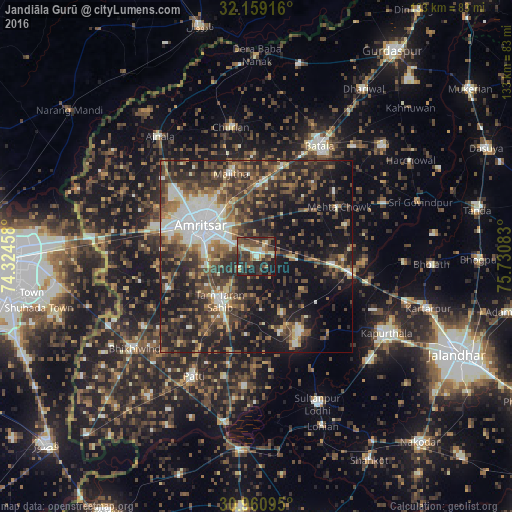
Analysis of Jandiāla Gurū night lights 2016
Square area 10x10 km:
 1.22%
1.22%90-99
9.09%80-89
5.24%70-79
3.85%60-69
7.52%50-59
7.17%40-49
17.31%30-39
12.94%20-29
20.1%10-19
15.38%0-9
0.17%Square area 50x50 km:
4.18%90-99
6.31%80-89
3.03%70-79
3.01%60-69
5.24%50-59
7.05%40-49
10.07%30-39
10.19%20-29
13.08%10-19
23.13%0-9
14.7%Clear (daylight) street map image can be seen on geolist.org.
Map coordinates:
32° 9' 33" North, 74° 19' 28.5" East
31° 33' 43.1" North, 75° 1' 39.7" East
30° 57' 39.4" North, 75° 43' 51" East
Some cities around Jandiāla Gurū sort by population:
• Amritsar
15.9 km =9.9 mi,  294°
294°
• Batāla
32.1 km =19.9 mi,  31°
31°
• Tarn Tāran
15.5 km =9.6 mi,  217°
217°
• Patti
35.1 km =21.8 mi,  207°
207°
• Fatehgarh Chūriān
34.3 km =21.3 mi,  348°
348°
• Majītha
22.7 km =14.1 mi,  343°
343°
• Rāja Sānsi
27.8 km =17.3 mi,  309°
309°
• Dhilwan
30.6 km =19 mi,  99°
99°
1269267 (p: 8,155)
Sources (retrieved 2019-11-25):
» Earth at Night: Flat Maps 2012, 2016