Fatehgarh Chūriān night lights from space
Night Light of Fatehgarh Chūriān (Punjab) from space (India) Src. Average luminocity for 10x10km area is 18.9835% and for 50x50km: 22.6397%.
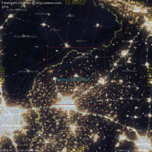
Analysis of Fatehgarh Chūriān night lights 2016
Square area 10x10 km:
 0.37%
0.37%90-99
1.28%80-89
2.01%70-79
1.47%60-69
0.92%50-59
2.2%40-49
6.23%30-39
6.41%20-29
6.41%10-19
27.11%0-9
45.6%Square area 50x50 km:
2.11%90-99
3.76%80-89
1.46%70-79
1.45%60-69
2.61%50-59
4.67%40-49
6.82%30-39
6.77%20-29
8.08%10-19
13.09%0-9
49.18%Clear (daylight) street map image can be seen on geolist.org.
Map coordinates:
32° 27' 34.3" North, 74° 15' 12.7" East
31° 51' 51.5" North, 74° 57' 23.9" East
31° 15' 54.8" North, 75° 39' 35.2" East
Some cities around Fatehgarh Chūriān sort by population:
• Batāla
24.1 km =15 mi,  104°
104°
• Narowal, PK
27.6 km =17.1 mi,  343°
343°
• Ajnāla
18.4 km =11.4 mi,  263°
263°
• Majītha
11.9 km =7.4 mi,  178°
178°
• Kalanaur
24.6 km =15.3 mi,  48°
48°
• Rāja Sānsi
21.8 km =13.5 mi,  222°
222°
• Derā Nānak
20.4 km =12.7 mi,  19°
19°
• Rām Dās
12.3 km =7.6 mi, 338°
1271923 (p: 18,051)
Sources (retrieved 2019-11-25):
» Earth at Night: Flat Maps 2012, 2016