Majītha night lights from space
Night Light of Majītha (Punjab) from space (India) Src. Average luminocity for 10x10km area is 44.1337% and for 50x50km: 32.2357%.
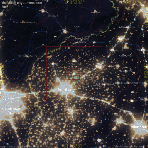
Analysis of Majītha night lights 2016
Square area 10x10 km:
 1.83%
1.83%90-99
2.93%80-89
4.58%70-79
2.93%60-69
8.42%50-59
11.36%40-49
20.33%30-39
19.23%20-29
18.68%10-19
9.71%0-9
0%Square area 50x50 km:
3.87%90-99
5.97%80-89
2.43%70-79
2.26%60-69
4.13%50-59
6.21%40-49
8.87%30-39
8.51%20-29
10.46%10-19
17%0-9
30.29%Clear (daylight) street map image can be seen on geolist.org.
Map coordinates:
32° 21' 10.9" North, 74° 15' 20.8" East
31° 45' 25.6" North, 74° 57' 32.1" East
31° 9' 26.4" North, 75° 39' 43.3" East
Some cities around Majītha sort by population:
• Amritsar
16.9 km =10.5 mi,  207°
207°
• Batāla
23.8 km =14.8 mi,  75°
75°
• Ajnāla
20.9 km =13 mi,  297°
297°
• Fatehgarh Chūriān
11.9 km =7.4 mi,  358°
358°
• Rāja Sānsi
15.5 km =9.6 mi,  254°
254°
• Jandiāla Gurū
22.7 km =14.1 mi,  163°
163°
• Derā Nānak
31.8 km =19.8 mi,  11°
11°
• Rām Dās
23.9 km =14.9 mi,  348°
348°
1264241 (p: 13,900)
Sources (retrieved 2019-11-25):
» Earth at Night: Flat Maps 2012, 2016