Gandevi night lights from space
Night Light of Gandevi (Gujarat) from space (India) Src. Average luminocity for 10x10km area is 26.7639% and for 50x50km: 11.6195%.
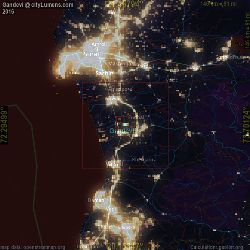
Analysis of Gandevi night lights 2016
Square area 10x10 km:
 0.4%
0.4%90-99
4.17%80-89
3.37%70-79
1.39%60-69
4.17%50-59
2.78%40-49
2.98%30-39
6.55%20-29
17.06%10-19
39.68%0-9
17.46%Square area 50x50 km:
0.29%90-99
1.7%80-89
1.71%70-79
0.91%60-69
1.51%50-59
1.64%40-49
2.08%30-39
2.75%20-29
4.58%10-19
12.14%0-9
70.7%Clear (daylight) street map image can be seen on geolist.org.
Map coordinates:
21° 28' 4.6" North, 72° 17' 42" East
20° 48' 43.7" North, 72° 59' 53.2" East
20° 9' 12.5" North, 73° 42' 4.5" East
Some cities around Gandevi sort by population:
• Bilimora
6.1 km =3.8 mi,  218°
218°
• Navsāri
16.4 km =10.2 mi,  332°
332°
• Valsād
23.4 km =14.5 mi,  196°
196°
• Abrama
10.8 km =6.7 mi,  298°
298°
• Jalālpur
18.4 km =11.4 mi, 325°
• Sachīn
32.9 km =20.4 mi,  338°
338°
• Parnera
28.4 km =17.6 mi,  190°
190°
• Chikhli
9.1 km =5.7 mi,  132°
132°
1271722 (p: 16,240)
Sources (retrieved 2019-11-25):
» Earth at Night: Flat Maps 2012, 2016