Jagannāthpur night lights from space
Night Light of Jagannāthpur (Jharkhand) from space (India) Src. Average luminocity for 10x10km area is 9.053% and for 50x50km: 10.3238%.
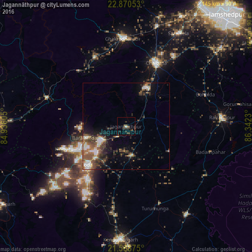
Analysis of Jagannāthpur night lights 2016
Square area 10x10 km:
 0.38%
0.38%90-99
0.38%80-89
0%70-79
0.76%60-69
0.76%50-59
2.65%40-49
2.27%30-39
5.11%20-29
4.36%10-19
1.33%0-9
82.01%Square area 50x50 km:
1.06%90-99
1.83%80-89
0.76%70-79
0.97%60-69
1.35%50-59
2.4%40-49
2.37%30-39
2.22%20-29
2.59%10-19
4.89%0-9
79.57%Clear (daylight) street map image can be seen on geolist.org.
Map coordinates:
22° 52' 13.9" North, 84° 56' 9.8" East
22° 13' 16.1" North, 85° 38' 21" East
21° 34' 7.5" North, 86° 20' 32.3" East
Some cities around Jagannāthpur sort by population:
• Chāībāsa
40.3 km =25 mi,  24°
24°
• Bada Barabīl
28.7 km =17.8 mi,  244°
244°
• Barbil
30 km =18.6 mi, 243°
• Noāmundi
15.4 km =9.6 mi, 244°
• Bolānīkhodān
33.4 km =20.8 mi,  248°
248°
• Gua
25.9 km =16.1 mi,  268°
268°
• Kiri Buru
33.5 km =20.8 mi, 242°
• Chāmpua
17.3 km =10.7 mi,  171°
171°
1269592 (p: 7,020)
Sources (retrieved 2019-11-25):
» Earth at Night: Flat Maps 2012, 2016