Gua night lights from space
Night Light of Gua (Jharkhand) from space (India) Src. Average luminocity for 10x10km area is 24.7822% and for 50x50km: 15.0816%.
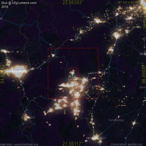
Analysis of Gua night lights 2016
Square area 10x10 km:
 1.89%
1.89%90-99
3.79%80-89
1.52%70-79
2.65%60-69
3.6%50-59
2.65%40-49
4.36%30-39
4.73%20-29
13.83%10-19
25.19%0-9
35.8%Square area 50x50 km:
1.84%90-99
3.07%80-89
1.3%70-79
1.34%60-69
1.92%50-59
3.18%40-49
2.82%30-39
3.15%20-29
4.66%10-19
7.12%0-9
69.6%Clear (daylight) street map image can be seen on geolist.org.
Map coordinates:
22° 51' 46.9" North, 84° 41' 4.6" East
22° 12' 49" North, 85° 23' 15.9" East
21° 33' 40.2" North, 86° 5' 27.1" East
Some cities around Gua sort by population:
• Bada Barabīl
11.3 km =7 mi,  180°
180°
• Barbil
12.5 km =7.8 mi, 184°
• Noāmundi
13.3 km =8.3 mi,  116°
116°
• Manoharpur
26.9 km =16.7 mi,  311°
311°
• Bolānīkhodān
12.4 km =7.7 mi,  205°
205°
• Kiri Buru
15 km =9.3 mi,  195°
195°
• Chāmpua
32.8 km =20.4 mi, 119°
• Jagannāthpur
25.9 km =16.1 mi,  88°
88°
1270827 (p: 11,388)
Sources (retrieved 2019-11-25):
» Earth at Night: Flat Maps 2012, 2016