Noāmundi night lights from space
Night Light of Noāmundi (Jharkhand) from space (India) Src. Average luminocity for 10x10km area is 37.9464% and for 50x50km: 18.8463%.
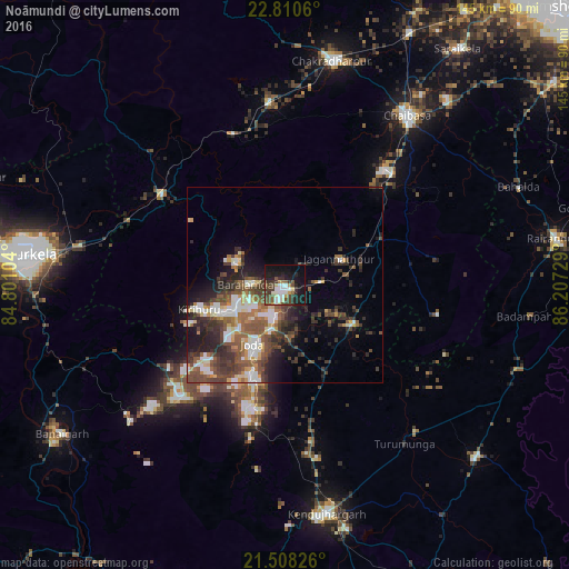
Analysis of Noāmundi night lights 2016
Square area 10x10 km:
 5.36%
5.36%90-99
9.13%80-89
3.37%70-79
2.38%60-69
1.98%50-59
5.95%40-49
10.91%30-39
7.74%20-29
9.72%10-19
29.96%0-9
13.49%Square area 50x50 km:
2.28%90-99
3.59%80-89
1.54%70-79
1.82%60-69
2.19%50-59
4.14%40-49
4.63%30-39
4.41%20-29
5.47%10-19
7.08%0-9
62.85%Clear (daylight) street map image can be seen on geolist.org.
Map coordinates:
22° 48' 38.2" North, 84° 48' 3.7" East
22° 9' 39.4" North, 85° 30' 15" East
21° 30' 29.7" North, 86° 12' 26.2" East
Some cities around Noāmundi sort by population:
• Bada Barabīl
13.3 km =8.3 mi,  245°
245°
• Barbil
14.6 km =9.1 mi,  243°
243°
• Manoharpur
39.9 km =24.8 mi,  306°
306°
• Bolānīkhodān
18.1 km =11.2 mi, 252°
• Gua
13.3 km =8.3 mi,  296°
296°
• Kiri Buru
18.1 km =11.2 mi, 241°
• Chāmpua
19.5 km =12.1 mi,  122°
122°
• Jagannāthpur
15.4 km =9.6 mi,  64°
64°
1261242 (p: 16,558)
Sources (retrieved 2019-11-25):
» Earth at Night: Flat Maps 2012, 2016