Chāmpua night lights from space
Night Light of Chāmpua (Odisha) from space (India) Src. Average luminocity for 10x10km area is 17.2282% and for 50x50km: 10.0645%.
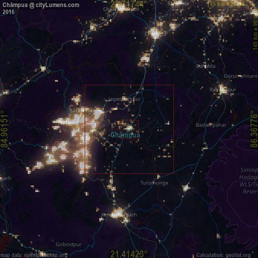
Analysis of Chāmpua night lights 2016
Square area 10x10 km:
 0.6%
0.6%90-99
1.79%80-89
0.6%70-79
3.17%60-69
0.99%50-59
1.98%40-49
6.94%30-39
5.56%20-29
6.75%10-19
4.76%0-9
66.87%Square area 50x50 km:
0.86%90-99
1.43%80-89
0.74%70-79
0.89%60-69
0.91%50-59
2.28%40-49
2.96%30-39
2.86%20-29
3.23%10-19
5.45%0-9
78.4%Clear (daylight) street map image can be seen on geolist.org.
Map coordinates:
22° 43' 2.8" North, 84° 57' 41.4" East
22° 4' 2.4" North, 85° 39' 52.7" East
21° 24' 51.2" North, 86° 22' 3.9" East
Some cities around Chāmpua sort by population:
• Chāībāsa
55.5 km =34.5 mi,  14°
14°
• Bada Barabīl
29 km =18 mi,  279°
279°
• Barbil
29.8 km =18.5 mi, 277°
• Noāmundi
19.5 km =12.1 mi,  302°
302°
• Bolānīkhodān
34.2 km =21.3 mi, 278°
• Gua
32.8 km =20.4 mi, 299°
• Kiri Buru
32.5 km =20.2 mi,  273°
273°
• Jagannāthpur
17.3 km =10.7 mi,  351°
351°
1274822 (p: 9,487)
Sources (retrieved 2019-11-25):
» Earth at Night: Flat Maps 2012, 2016