Kiri Buru night lights from space
Night Light of Kiri Buru (Odisha) from space (India) Src. Average luminocity for 10x10km area is 66.4405% and for 50x50km: 24.0935%.
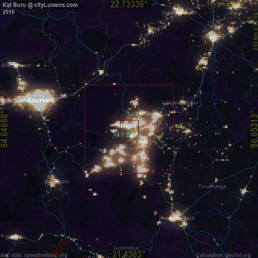
Analysis of Kiri Buru night lights 2016
Square area 10x10 km:
 14.29%
90-99
20.83%80-89
6.35%70-79
6.55%60-69
9.72%50-59
9.13%40-49
8.53%30-39
9.52%20-29
12.9%10-19
2.18%0-9
0%Square area 50x50 km:
3.05%90-99
4.79%80-89
2.07%70-79
2.16%60-69
2.66%50-59
5.3%40-49
5.86%30-39
5.51%20-29
6.9%10-19
11.01%0-9
50.68%Clear (daylight) street map image can be seen on geolist.org.
Map coordinates:
22° 44' 0.1" North, 84° 38' 48.8" East
22° 4' 60" North, 85° 21' 0" East
21° 25' 49.1" North, 86° 3' 11.3" East
Some cities around Kiri Buru sort by population:
• Bada Barabīl
4.9 km =3 mi,  50°
50°
• Barbil
3.5 km =2.2 mi, 53°
• Noāmundi
18.1 km =11.2 mi,  61°
61°
• Manoharpur
36.2 km =22.5 mi,  333°
333°
• Bolānīkhodān
3.6 km =2.2 mi,  337°
337°
• Gua
15 km =9.3 mi,  15°
15°
• Chāmpua
32.5 km =20.2 mi,  93°
93°
• Jagannāthpur
33.5 km =20.8 mi, 62°
1266503 (p: 9,719)
Sources (retrieved 2019-11-25):
» Earth at Night: Flat Maps 2012, 2016