Dewā night lights from space
Night Light of Dewā (Uttar Pradesh) from space (India) Src. Average luminocity for 10x10km area is 26.0794% and for 50x50km: 28.4393%.
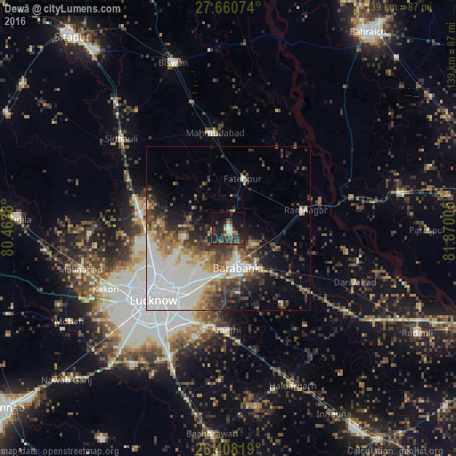
Analysis of Dewā night lights 2016
Square area 10x10 km:
 1.79%
1.79%90-99
1.79%80-89
3.17%70-79
2.18%60-69
2.18%50-59
1.98%40-49
6.75%30-39
10.71%20-29
13.49%10-19
30.75%0-9
25.2%Square area 50x50 km:
7.26%90-99
7.08%80-89
2.2%70-79
2.41%60-69
3.35%50-59
3.1%40-49
4.18%30-39
4.41%20-29
5.75%10-19
7.51%0-9
52.75%Clear (daylight) street map image can be seen on geolist.org.
Map coordinates:
27° 39' 38.7" North, 80° 27' 49.7" East
27° 2' 10.4" North, 81° 10' 0.9" East
26° 24' 29.5" North, 81° 52' 12.2" East
Some cities around Dewā sort by population:
• Nawābganj
12.1 km =7.5 mi,  165°
165°
• Mahmudābād
28.8 km =17.9 mi,  350°
350°
• Fatehpur
15.8 km =9.8 mi,  15°
15°
• Zaidpur
27.9 km =17.3 mi,  144°
144°
• Rāmnagar
24.3 km =15.1 mi,  77°
77°
• Satrikh
19.7 km =12.2 mi, 171°
• Goshāīnganj
30.4 km =18.9 mi,  191°
191°
• Itaunja
27.3 km =17 mi,  281°
281°
1273077 (p: 14,375)
Sources (retrieved 2019-11-25):
» Earth at Night: Flat Maps 2012, 2016