Ichhāwar night lights from space
Night Light of Ichhāwar (Madhya Pradesh) from space (India) Src. Average luminocity for 10x10km area is 4.8393% and for 50x50km: 5.5286%.
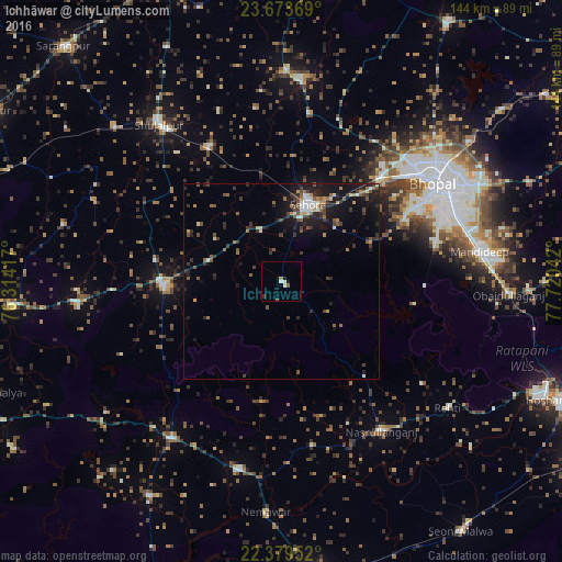
Analysis of Ichhāwar night lights 2016
Square area 10x10 km:
 0.6%
0.6%90-99
1.79%80-89
0%70-79
0%60-69
1.59%50-59
0.4%40-49
0%30-39
0.2%20-29
0.6%10-19
1.59%0-9
93.25%Square area 50x50 km:
0.38%90-99
0.72%80-89
0.31%70-79
0.51%60-69
0.71%50-59
1.08%40-49
1.07%30-39
1.34%20-29
1.96%10-19
4.71%0-9
87.22%Clear (daylight) street map image can be seen on geolist.org.
Map coordinates:
23° 40' 25.3" North, 76° 18' 51" East
23° 1' 41.4" North, 77° 1' 2.2" East
22° 22' 46.3" North, 77° 43' 13.5" East
Some cities around Ichhāwar sort by population:
• Bhopal
46.8 km =29.1 mi,  57°
57°
• Sehore
20.3 km =12.6 mi,  19°
19°
• Shujālpur
52.5 km =32.6 mi,  323°
323°
• Ashta
30.2 km =18.8 mi,  267°
267°
• Khātegaon
49.2 km =30.6 mi,  192°
192°
• Nasrullāhganj
46.3 km =28.8 mi,  145°
145°
• Kannod
49 km =30.4 mi,  215°
215°
• Iāwar
52.9 km =32.9 mi, 267°
1269824 (p: 13,656)
Sources (retrieved 2019-11-25):
» Earth at Night: Flat Maps 2012, 2016