Kannod night lights from space
Night Light of Kannod (Madhya Pradesh) from space (India) Src. Average luminocity for 10x10km area is 18.1687% and for 50x50km: 5.0642%.
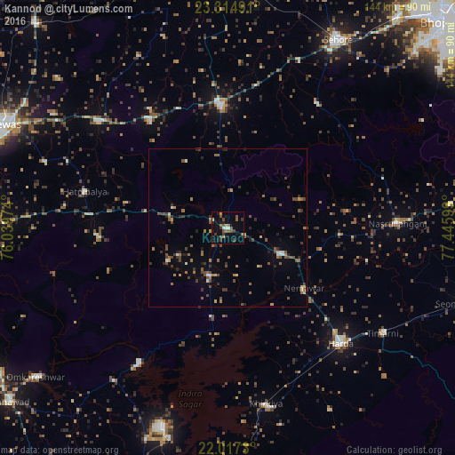
Analysis of Kannod night lights 2016
Square area 10x10 km:
 1.79%
1.79%90-99
0.6%80-89
1.39%70-79
1.79%60-69
2.78%50-59
4.76%40-49
4.37%30-39
4.76%20-29
2.38%10-19
7.74%0-9
67.66%Square area 50x50 km:
0.19%90-99
0.35%80-89
0.36%70-79
0.46%60-69
0.85%50-59
1.17%40-49
1.5%30-39
1.09%20-29
1.08%10-19
1.14%0-9
91.81%Clear (daylight) street map image can be seen on geolist.org.
Map coordinates:
23° 18' 53.7" North, 76° 2' 23.1" East
22° 40' 3.5" North, 76° 44' 34.3" East
22° 1' 2.3" North, 77° 26' 45.6" East
Some cities around Kannod sort by population:
• Harda Khās
51 km =31.7 mi,  134°
134°
• Ashta
39 km =24.2 mi,  356°
356°
• Khātegaon
19.2 km =11.9 mi,  114°
114°
• Nasrullāhganj
54.2 km =33.7 mi,  88°
88°
• Ichhāwar
49 km =30.4 mi,  35°
35°
• Satwās
15.8 km =9.8 mi,  202°
202°
• Bāgli
40.5 km =25.2 mi,  265°
265°
• Iāwar
45.4 km =28.2 mi,  326°
326°
1268007 (p: 15,870)
Sources (retrieved 2019-11-25):
» Earth at Night: Flat Maps 2012, 2016