Nasrullāhganj night lights from space
Night Light of Nasrullāhganj (Madhya Pradesh) from space (India) Src. Average luminocity for 10x10km area is 18.3889% and for 50x50km: 4.1694%.
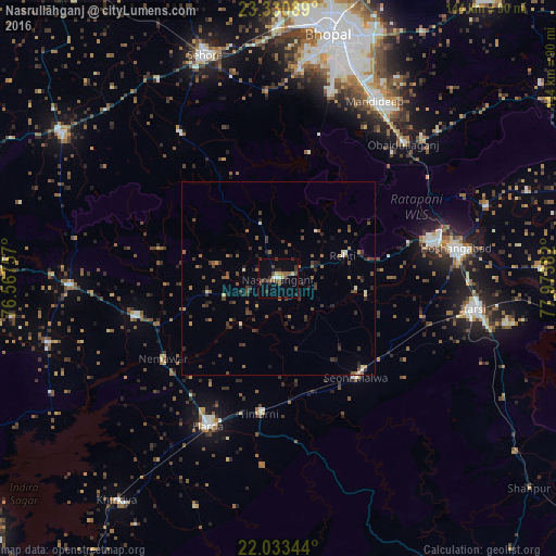
Analysis of Nasrullāhganj night lights 2016
Square area 10x10 km:
 1.59%
1.59%90-99
0.79%80-89
1.79%70-79
1.39%60-69
1.98%50-59
3.57%40-49
5.56%30-39
5.75%20-29
3.37%10-19
4.76%0-9
69.44%Square area 50x50 km:
0.12%90-99
0.32%80-89
0.21%70-79
0.31%60-69
0.56%50-59
0.97%40-49
1.03%30-39
1.72%20-29
1.09%10-19
0.94%0-9
92.73%Clear (daylight) street map image can be seen on geolist.org.
Map coordinates:
23° 19' 51.2" North, 76° 34' 3.3" East
22° 41' 1.3" North, 77° 16' 14.5" East
22° 2' 0.4" North, 77° 58' 25.8" East
Some cities around Nasrullāhganj sort by population:
• Hoshangābād
47.4 km =29.5 mi,  81°
81°
• Itārsi
51 km =31.7 mi,  98°
98°
• Harda Khās
41.8 km =26 mi,  205°
205°
• Mandideep
51.8 km =32.2 mi,  31°
31°
• Seoni Mālwa
32.8 km =20.4 mi,  142°
142°
• Khātegaon
38 km =23.6 mi,  255°
255°
• Ichhāwar
46.3 km =28.8 mi,  325°
325°
• Rehti
17.8 km =11.1 mi,  70°
70°
1261721 (p: 18,265)
Sources (retrieved 2019-11-25):
» Earth at Night: Flat Maps 2012, 2016