Rānīpur night lights from space
Night Light of Rānīpur (Uttar Pradesh) from space (India) Src. Average luminocity for 10x10km area is 21.5536% and for 50x50km: 8.0726%.
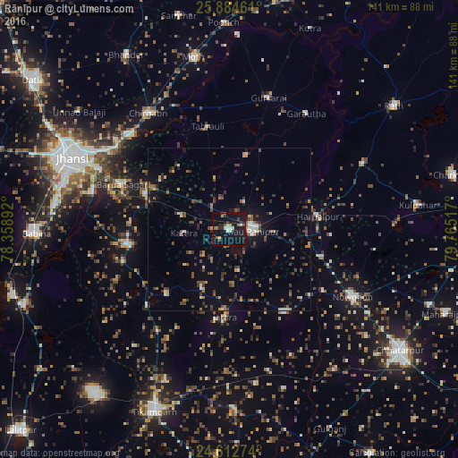
Analysis of Rānīpur night lights 2016
Square area 10x10 km:
 2.18%
2.18%90-99
2.38%80-89
2.18%70-79
1.98%60-69
1.79%50-59
3.17%40-49
1.79%30-39
2.78%20-29
5.36%10-19
41.07%0-9
35.32%Square area 50x50 km:
0.43%90-99
0.75%80-89
0.45%70-79
0.69%60-69
1.13%50-59
1.35%40-49
1.88%30-39
2.06%20-29
1.86%10-19
4.89%0-9
84.52%Clear (daylight) street map image can be seen on geolist.org.
Map coordinates:
25° 53' 4.6" North, 78° 21' 32.1" East
25° 15' 1.2" North, 79° 3' 43.3" East
24° 36' 45.9" North, 79° 45' 54.6" East
Some cities around Rānīpur sort by population:
• Gursarāi
42.4 km =26.3 mi,  16°
16°
• Harpālpur
27.5 km =17.1 mi,  81°
81°
• Jatāra
26.8 km =16.7 mi,  182°
182°
• Palera
30.6 km =19 mi,  146°
146°
• Tori-Fatehpur
23.4 km =14.5 mi,  12°
12°
• Garautha
42.9 km =26.7 mi,  33°
33°
• Barāgaon
43.2 km =26.8 mi,  305°
305°
• Pārīchha
41.8 km =26 mi, 313°
1258449 (p: 18,820)
Sources (retrieved 2019-11-25):
» Earth at Night: Flat Maps 2012, 2016