Hājipur night lights from space
Night Light of Hājipur (Punjab) from space (India) Src. Average luminocity for 10x10km area is 3.736% and for 50x50km: 4.6913%.
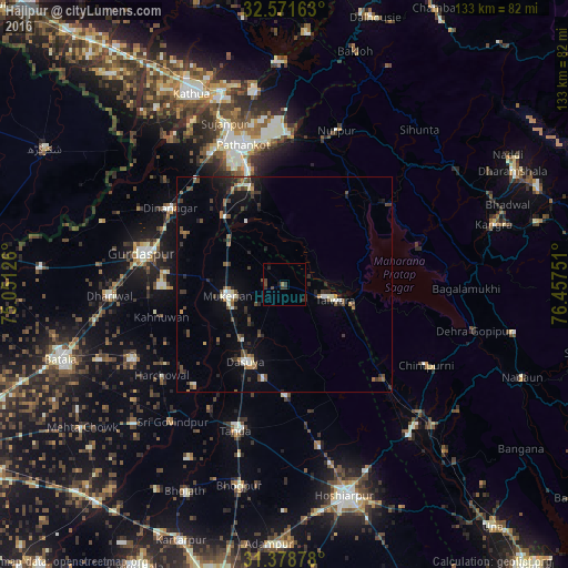
Analysis of Hājipur night lights 2016
Square area 10x10 km:
 0%
0%90-99
0%80-89
0%70-79
0%60-69
0.7%50-59
0.17%40-49
2.1%30-39
3.32%20-29
1.75%10-19
1.4%0-9
90.56%Square area 50x50 km:
0.25%90-99
0.63%80-89
0.25%70-79
0.22%60-69
0.6%50-59
0.72%40-49
1.27%30-39
1.11%20-29
1.26%10-19
2.52%0-9
91.17%Clear (daylight) street map image can be seen on geolist.org.
Map coordinates:
32° 34' 17.9" North, 75° 3' 4.5" East
31° 58' 37.7" North, 75° 45' 15.8" East
31° 22' 43.6" North, 76° 27' 27" East
Some cities around Hājipur sort by population:
• Pathānkot
34.5 km =21.4 mi,  343°
343°
• Talwāra
13.2 km =8.2 mi,  109°
109°
• Dīnānagar
31.9 km =19.8 mi,  303°
303°
• Mukeriān
13.2 km =8.2 mi,  258°
258°
• Dasūya
20.2 km =12.6 mi,  208°
208°
• Hariāna
38.9 km =24.2 mi,  168°
168°
• Garhdiwāla
26.2 km =16.3 mi,  179°
179°
• Nagrota
33 km =20.5 mi,  74°
74°
1270523 (p: 5,680)
Sources (retrieved 2019-11-25):
» Earth at Night: Flat Maps 2012, 2016