Chāndor night lights from space
Night Light of Chāndor (Maharashtra) from space (India) Src. Average luminocity for 10x10km area is 14.7803% and for 50x50km: 9.6639%.
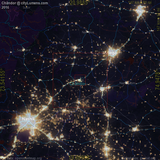
Analysis of Chāndor night lights 2016
Square area 10x10 km:
 0%
0%90-99
3.6%80-89
2.08%70-79
0.38%60-69
1.52%50-59
3.03%40-49
2.84%30-39
1.52%20-29
3.6%10-19
5.11%0-9
76.33%Square area 50x50 km:
0.08%90-99
0.84%80-89
0.63%70-79
0.5%60-69
1.09%50-59
1.64%40-49
2.76%30-39
3.4%20-29
4.44%10-19
8.1%0-9
76.52%Clear (daylight) street map image can be seen on geolist.org.
Map coordinates:
20° 59' 18.6" North, 73° 32' 29.6" East
20° 19' 50.2" North, 74° 14' 40.8" East
19° 40' 11.6" North, 74° 56' 52.1" East
Some cities around Chāndor sort by population:
• Mālegaon
38.8 km =24.1 mi,  51°
51°
• Manmād
21.9 km =13.6 mi,  113°
113°
• Kopargaon
55.4 km =34.4 mi,  154°
154°
• Yeola
41 km =25.5 mi,  141°
141°
• Ozar
42.2 km =26.2 mi,  231°
231°
• Satānā
29.7 km =18.5 mi,  351°
351°
• Nāndgaon
42.9 km =26.7 mi,  93°
93°
• Lāsalgaon
20.9 km =13 mi,  181°
181°
1274673 (p: 19,592)
Sources (retrieved 2019-11-25):
» Earth at Night: Flat Maps 2012, 2016