Chandia night lights from space
Night Light of Chandia (Madhya Pradesh) from space (India) Src. Average luminocity for 10x10km area is 10.2817% and for 50x50km: 4.4935%.
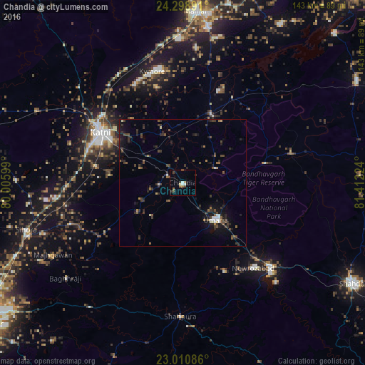
Analysis of Chandia night lights 2016
Square area 10x10 km:
 1.79%
1.79%90-99
0.6%80-89
0.79%70-79
0.4%60-69
2.58%50-59
1.39%40-49
1.98%30-39
1.19%20-29
2.38%10-19
0.79%0-9
86.11%Square area 50x50 km:
0.31%90-99
0.34%80-89
0.22%70-79
0.16%60-69
0.58%50-59
0.77%40-49
1.08%30-39
1.54%20-29
1.87%10-19
3.06%0-9
90.08%Clear (daylight) street map image can be seen on geolist.org.
Map coordinates:
24° 17' 56.1" North, 80° 0' 21.6" East
23° 39' 23.3" North, 80° 42' 32.8" East
23° 0' 39.1" North, 81° 24' 44.1" East
Some cities around Chandia sort by population:
• Murwāra
37.9 km =23.5 mi,  302°
302°
• Sihorā
64.5 km =40.1 mi,  253°
253°
• Maihar
68 km =42.3 mi,  4°
4°
• Umaria
19.6 km =12.2 mi,  138°
138°
• Pāli
47.1 km =29.3 mi,  133°
133°
• Barhi
29.5 km =18.3 mi,  21°
21°
• Shāhpur
76.4 km =47.5 mi,  156°
156°
• Jaisinghnagar
69.5 km =43.2 mi,  87°
87°
1274747 (p: 13,099)
Sources (retrieved 2019-11-25):
» Earth at Night: Flat Maps 2012, 2016