Barhi night lights from space
Night Light of Barhi (Madhya Pradesh) from space (India) Src. Average luminocity for 10x10km area is 10.3631% and for 50x50km: 5.813%.
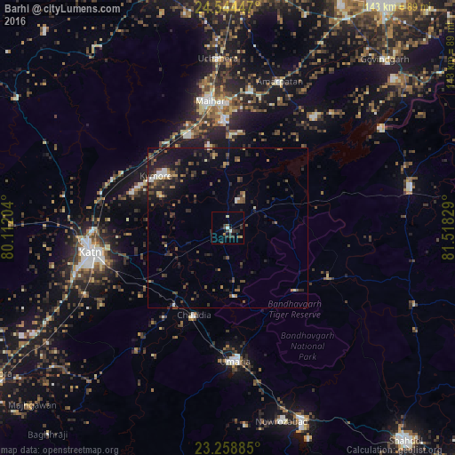
Analysis of Barhi night lights 2016
Square area 10x10 km:
 0.6%
0.6%90-99
0.99%80-89
1.59%70-79
0%60-69
1.39%50-59
0.99%40-49
1.39%30-39
5.16%20-29
4.37%10-19
2.78%0-9
80.75%Square area 50x50 km:
0.34%90-99
0.53%80-89
0.34%70-79
0.33%60-69
0.74%50-59
1.15%40-49
1.32%30-39
1.55%20-29
2.57%10-19
4.46%0-9
86.67%Clear (daylight) street map image can be seen on geolist.org.
Map coordinates:
24° 32' 40.1" North, 80° 6' 43.3" East
23° 54' 11.7" North, 80° 48' 54.6" East
23° 15' 31.9" North, 81° 31' 5.8" East
Some cities around Barhi sort by population:
• Murwāra
43.4 km =27 mi,  260°
260°
• Maihar
40.7 km =25.3 mi,  352°
352°
• Umaria
42.1 km =26.2 mi,  176°
176°
• Beohāri
58.8 km =36.5 mi,  76°
76°
• Pāli
64.3 km =40 mi,  158°
158°
• Amarpātan
48.5 km =30.1 mi,  19°
19°
• Chandia
29.5 km =18.3 mi,  201°
201°
• Jaisinghnagar
63.4 km =39.4 mi,  112°
112°
1276956 (p: 12,136)
Sources (retrieved 2019-11-25):
» Earth at Night: Flat Maps 2012, 2016