Būndu night lights from space
Night Light of Būndu (Jharkhand) from space (India) Src. Average luminocity for 10x10km area is 24.4697% and for 50x50km: 8.1444%.
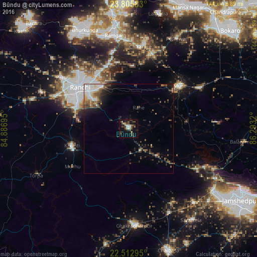
Analysis of Būndu night lights 2016
Square area 10x10 km:
 2.65%
2.65%90-99
2.65%80-89
1.7%70-79
3.41%60-69
1.7%50-59
1.7%40-49
10.04%30-39
6.44%20-29
6.06%10-19
19.51%0-9
44.13%Square area 50x50 km:
1.68%90-99
1.08%80-89
0.54%70-79
0.84%60-69
0.67%50-59
1.28%40-49
1.88%30-39
1.6%20-29
1.98%10-19
3.83%0-9
84.62%Clear (daylight) street map image can be seen on geolist.org.
Map coordinates:
23° 48' 21" North, 84° 53' 13" East
23° 9' 39.4" North, 85° 35' 24.3" East
22° 30' 46.6" North, 86° 17' 35.5" East
Some cities around Būndu sort by population:
• Ranchi
35.1 km =21.8 mi,  305°
305°
• Rāmgarh
52.7 km =32.7 mi,  352°
352°
• Khunti
33.3 km =20.7 mi,  253°
253°
• Barkā Kānā
52.7 km =32.7 mi, 346°
• Jhalidā
45.5 km =28.3 mi,  60°
60°
• Kānke
41 km =25.5 mi,  317°
317°
• Muri
36.3 km =22.6 mi,  50°
50°
• Kharsāwān
48 km =29.8 mi,  149°
149°
1275097 (p: 19,467)
Sources (retrieved 2019-11-25):
» Earth at Night: Flat Maps 2012, 2016