Muri night lights from space
Night Light of Muri (West Bengal) from space (India) Src. Average luminocity for 10x10km area is 33.4867% and for 50x50km: 9.5405%.
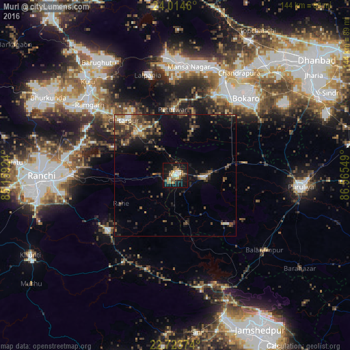
Analysis of Muri night lights 2016
Square area 10x10 km:
 3.41%
3.41%90-99
5.11%80-89
3.6%70-79
3.79%60-69
8.9%50-59
4.92%40-49
3.41%30-39
2.65%20-29
9.28%10-19
39.96%0-9
14.96%Square area 50x50 km:
0.46%90-99
0.93%80-89
0.74%70-79
0.92%60-69
1.4%50-59
1.86%40-49
2.34%30-39
2.69%20-29
3.36%10-19
7.6%0-9
77.7%Clear (daylight) street map image can be seen on geolist.org.
Map coordinates:
24° 0' 52.6" North, 85° 9' 33.3" East
23° 22' 14.7" North, 85° 51' 44.5" East
22° 43' 25.5" North, 86° 33' 55.8" East
Some cities around Muri sort by population:
• Bokāro
47.3 km =29.4 mi,  11°
11°
• Chās
42.8 km =26.6 mi,  46°
46°
• Rāmgarh
45.2 km =28.1 mi,  309°
309°
• Gumia
47.6 km =29.6 mi,  355°
355°
• Balarāmpur
47.8 km =29.7 mi,  129°
129°
• Būndu
36.3 km =22.6 mi,  230°
230°
• Barkā Kānā
49 km =30.4 mi,  304°
304°
• Jhalidā
11.7 km =7.3 mi,  92°
92°
1262429 (p: 12,656)
Sources (retrieved 2019-11-25):
» Earth at Night: Flat Maps 2012, 2016