Kharsāwān night lights from space
Night Light of Kharsāwān (Jharkhand) from space (India) Src. Average luminocity for 10x10km area is 20.5655% and for 50x50km: 14.5177%.
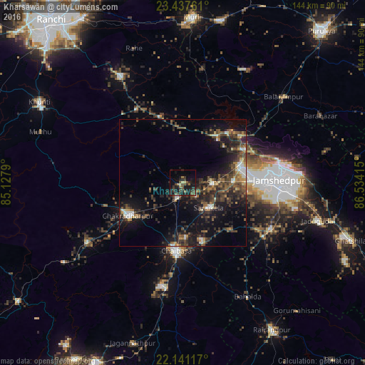
Analysis of Kharsāwān night lights 2016
Square area 10x10 km:
 0%
0%90-99
0.79%80-89
2.18%70-79
0.6%60-69
2.78%50-59
2.38%40-49
8.73%30-39
7.74%20-29
10.71%10-19
25.2%0-9
38.89%Square area 50x50 km:
0.9%90-99
1.5%80-89
0.94%70-79
1.16%60-69
1.6%50-59
2.92%40-49
3.94%30-39
4.49%20-29
6.9%10-19
11.79%0-9
63.84%Clear (daylight) street map image can be seen on geolist.org.
Map coordinates:
23° 26' 15.4" North, 85° 7' 40.4" East
22° 47' 27.3" North, 85° 49' 51.7" East
22° 8' 28.2" North, 86° 32' 2.9" East
Some cities around Kharsāwān sort by population:
• Chāībāsa
26.9 km =16.7 mi,  186°
186°
• Jugsālai
36.2 km =22.5 mi,  92°
92°
• Chakradharpur
24.3 km =15.1 mi,  238°
238°
• Gobindpur
30.2 km =18.8 mi,  125°
125°
• Saraikela
14.4 km =8.9 mi, 134°
• Kāndra
23.6 km =14.7 mi,  73°
73°
• Sini
11.7 km =7.3 mi, 88°
• Gopināthpur
28.8 km =17.9 mi,  119°
119°
1266873 (p: 7,216)
Sources (retrieved 2019-11-25):
» Earth at Night: Flat Maps 2012, 2016