Jhalidā night lights from space
Night Light of Jhalidā (West Bengal) from space (India) Src. Average luminocity for 10x10km area is 15.6705% and for 50x50km: 6.4583%.
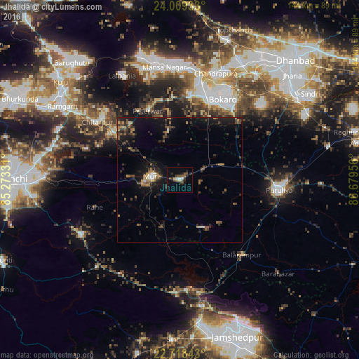
Analysis of Jhalidā night lights 2016
Square area 10x10 km:
 1.14%
1.14%90-99
1.89%80-89
1.89%70-79
0.38%60-69
1.52%50-59
3.6%40-49
3.79%30-39
2.65%20-29
3.6%10-19
5.49%0-9
74.05%Square area 50x50 km:
0.22%90-99
0.46%80-89
0.39%70-79
0.63%60-69
0.93%50-59
1.04%40-49
1.48%30-39
1.76%20-29
2.58%10-19
6.4%0-9
84.13%Clear (daylight) street map image can be seen on geolist.org.
Map coordinates:
24° 0' 33.6" North, 85° 16' 23.9" East
23° 21' 55.6" North, 85° 58' 35.1" East
22° 43' 6.3" North, 86° 40' 46.4" East
Some cities around Jhalidā sort by population:
• Bokāro
46.9 km =29.1 mi,  357°
357°
• Puruliya
39.7 km =24.7 mi,  95°
95°
• Chās
35.8 km =22.2 mi,  32°
32°
• Gumia
50.4 km =31.3 mi,  342°
342°
• Balarāmpur
39 km =24.2 mi,  139°
139°
• Dugda
46.7 km =29 mi, 25°
• Būndu
45.5 km =28.3 mi,  240°
240°
• Muri
11.7 km =7.3 mi,  272°
272°
1269026 (p: 18,057)
Sources (retrieved 2019-11-25):
» Earth at Night: Flat Maps 2012, 2016