Bijni night lights from space
Night Light of Bijni (Assam) from space (India) Src. Average luminocity for 10x10km area is 11.286% and for 50x50km: 6.241%.
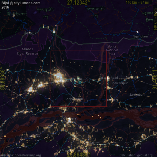
Analysis of Bijni night lights 2016
Square area 10x10 km:
 0.19%
0.19%90-99
1.33%80-89
0.76%70-79
0.76%60-69
1.7%50-59
1.33%40-49
3.22%30-39
2.65%20-29
5.87%10-19
4.17%0-9
78.03%Square area 50x50 km:
0.59%90-99
0.86%80-89
0.53%70-79
0.27%60-69
0.75%50-59
0.88%40-49
1.58%30-39
1.44%20-29
2.88%10-19
3.89%0-9
86.33%Clear (daylight) street map image can be seen on geolist.org.
Map coordinates:
27° 7' 24.3" North, 89° 59' 59.5" East
26° 29' 45.2" North, 90° 42' 10.7" East
25° 51' 53.6" North, 91° 24' 22" East
Some cities around Bijni sort by population:
• Bongaigaon
14.6 km =9.1 mi,  261°
261°
• Barpeta
35.8 km =22.2 mi,  122°
122°
• Barpeta Road
26.5 km =16.5 mi,  88°
88°
• Chāpar
35.7 km =22.2 mi,  225°
225°
• Howli
28.8 km =17.9 mi,  106°
106°
• Abhayāpuri
19.4 km =12.1 mi,  185°
185°
• Bāsugaon
28.4 km =17.6 mi, 263°
• Sorbhog
18.2 km =11.3 mi, 93°
1275682 (p: 12,990)
Sources (retrieved 2019-11-25):
» Earth at Night: Flat Maps 2012, 2016