Sorbhog night lights from space
Night Light of Sorbhog (Assam) from space (India) Src. Average luminocity for 10x10km area is 6.0852% and for 50x50km: 3.1366%.
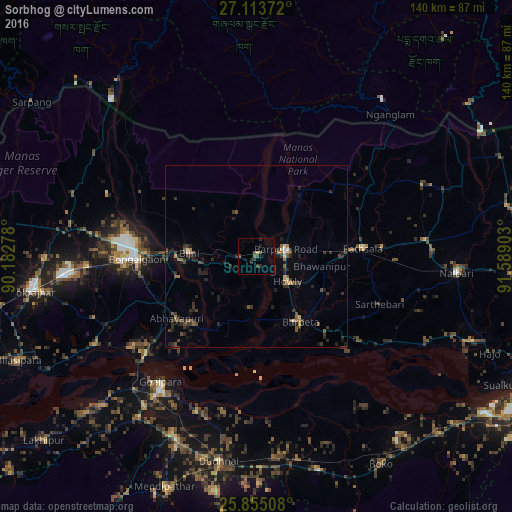
Analysis of Sorbhog night lights 2016
Square area 10x10 km:
 0%
0%90-99
0.19%80-89
0.57%70-79
0%60-69
0.57%50-59
0.57%40-49
2.65%30-39
2.08%20-29
3.22%10-19
1.33%0-9
88.83%Square area 50x50 km:
0.06%90-99
0.15%80-89
0.15%70-79
0.17%60-69
0.44%50-59
0.55%40-49
0.9%30-39
1.15%20-29
1.79%10-19
1.22%0-9
93.41%Clear (daylight) street map image can be seen on geolist.org.
Map coordinates:
27° 6' 49.4" North, 90° 10' 58" East
26° 29' 10" North, 90° 53' 9.2" East
25° 51' 18.3" North, 91° 35' 20.5" East
Some cities around Sorbhog sort by population:
• Bongaigaon
32.6 km =20.3 mi,  268°
268°
• Goālpāra
43 km =26.7 mi,  216°
216°
• Barpeta
21.8 km =13.5 mi,  146°
146°
• Barpeta Road
8.5 km =5.3 mi,  77°
77°
• Howli
11.8 km =7.3 mi,  127°
127°
• Abhayāpuri
27 km =16.8 mi,  227°
227°
• Bijni
18.2 km =11.3 mi, 273°
• Bāsugaon
46.5 km =28.9 mi, 267°
1255708 (p: 7,614)
Sources (retrieved 2019-11-25):
» Earth at Night: Flat Maps 2012, 2016