Chāpar night lights from space
Night Light of Chāpar (Assam) from space (India) Src. Average luminocity for 10x10km area is 4.5794% and for 50x50km: 11.8459%.
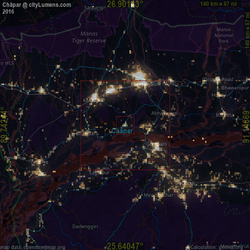
Analysis of Chāpar night lights 2016
Square area 10x10 km:
 0%
0%90-99
0%80-89
0%70-79
0.79%60-69
0.79%50-59
1.59%40-49
0.79%30-39
0.79%20-29
4.76%10-19
0.79%0-9
89.68%Square area 50x50 km:
0.67%90-99
1.06%80-89
0.69%70-79
0.76%60-69
1.55%50-59
2.31%40-49
3.36%30-39
2.94%20-29
4.65%10-19
11.55%0-9
70.47%Clear (daylight) street map image can be seen on geolist.org.
Map coordinates:
26° 54' 5.1" North, 89° 44' 32.8" East
26° 16' 21.6" North, 90° 26' 44" East
25° 38' 25.7" North, 91° 8' 55.3" East
Some cities around Chāpar sort by population:
• Bongaigaon
25.3 km =15.7 mi,  26°
26°
• Goālpāra
21 km =13 mi,  120°
120°
• Bilāsipāra
21.5 km =13.4 mi,  258°
258°
• Kokrajhar
22.4 km =13.9 mi,  309°
309°
• Abhayāpuri
24.5 km =15.2 mi,  76°
76°
• Lakhipur
30.4 km =18.9 mi,  207°
207°
• Bāsugaon
21.8 km =13.5 mi,  353°
353°
• Sapatgrām
32.9 km =20.4 mi,  282°
282°
1274618 (p: 19,301)
Sources (retrieved 2019-11-25):
» Earth at Night: Flat Maps 2012, 2016