Howli night lights from space
Night Light of Howli (Assam) from space (India) Src. Average luminocity for 10x10km area is 9.4299% and for 50x50km: 2.461%.
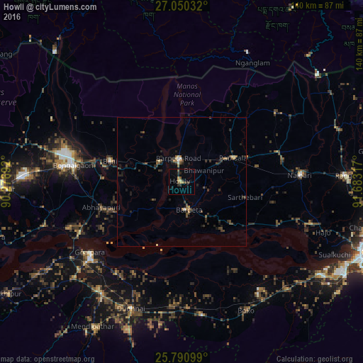
Analysis of Howli night lights 2016
Square area 10x10 km:
 0%
0%90-99
0%80-89
0.76%70-79
2.65%60-69
0.38%50-59
1.89%40-49
1.14%30-39
3.22%20-29
3.22%10-19
3.41%0-9
83.33%Square area 50x50 km:
0.05%90-99
0.1%80-89
0.25%70-79
0.14%60-69
0.42%50-59
0.3%40-49
0.66%30-39
0.8%20-29
1.29%10-19
0.96%0-9
95.02%Clear (daylight) street map image can be seen on geolist.org.
Map coordinates:
27° 3' 1.2" North, 90° 16' 36.9" East
26° 25' 20.5" North, 90° 58' 48.1" East
25° 47' 27.6" North, 91° 40' 59.4" East
Some cities around Howli sort by population:
• Bongaigaon
42.4 km =26.3 mi,  278°
278°
• Goālpāra
44.6 km =27.7 mi,  232°
232°
• Barpeta
11.4 km =7.1 mi,  166°
166°
• Barpeta Road
9 km =5.6 mi,  353°
353°
• Chāpar
55.8 km =34.7 mi,  252°
252°
• Abhayāpuri
31.4 km =19.5 mi, 249°
• Bijni
28.8 km =17.9 mi,  286°
286°
• Sorbhog
11.8 km =7.3 mi,  307°
307°
1269927 (p: 17,354)
Sources (retrieved 2019-11-25):
» Earth at Night: Flat Maps 2012, 2016