Bagra night lights from space
Night Light of Bagra (Jharkhand) from space (India) Src. Average luminocity for 10x10km area is 74.4127% and for 50x50km: 54.4252%.
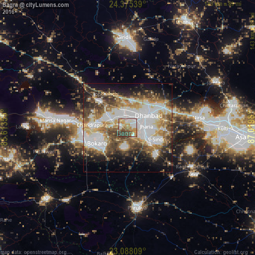
Analysis of Bagra night lights 2016
Square area 10x10 km:
100  16.07%
90-99 21.03%
80-89 8.53%
70-79 16.07%
60-69 13.1%
50-59 3.57%
40-49 8.73%
30-39 12.7%
20-29 0.2%
10-19 0%
0-9 0%
16.07%90-99
21.03%80-89
8.53%70-79
16.07%60-69
13.1%50-59
3.57%40-49
8.73%30-39
12.7%20-29
0.2%10-19
0%0-9
0%Square area 50x50 km:
100 14.98%
90-99 12.03%
80-89 5.96%
70-79 5.99%
60-69 7.24%
50-59 7.34%
40-49 8.04%
30-39 7.56%
20-29 6.19%
10-19 9.7%
0-9 14.98%
14.98%90-99
12.03%80-89
5.96%70-79
5.99%60-69
7.24%50-59
7.34%40-49
8.04%30-39
7.56%20-29
6.19%10-19
9.7%0-9
14.98%Clear (daylight) street map image can be seen on geolist.org.
Map coordinates:
24° 22' 31.4" North, 85° 36' 48.8" East
23° 43' 60" North, 86° 19' 0" East
23° 5' 17.1" North, 87° 1' 11.3" East
Some cities around Bagra sort by population:
• Jharia
10 km =6.2 mi,  85°
85°
• Kātrās
7.4 km =4.6 mi,  345°
345°
• Pāthardih
13.9 km =8.6 mi,  122°
122°
• Jāmadoba
8.7 km =5.4 mi,  102°
102°
• Sijua
5 km =3.1 mi,  16°
16°
• Dugda
14.8 km =9.2 mi,  275°
275°
• Malkera
6.2 km =3.9 mi,  331°
331°
• Kenduadīh
7.7 km =4.8 mi,  52°
52°
1277863 (p: 11,364)
Sources (retrieved 2019-11-25):
» Earth at Night: Flat Maps 2012, 2016