Bhawānīgarh night lights from space
Night Light of Bhawānīgarh (Punjab) from space (India) Src. Average luminocity for 10x10km area is 18.4231% and for 50x50km: 15.23%.
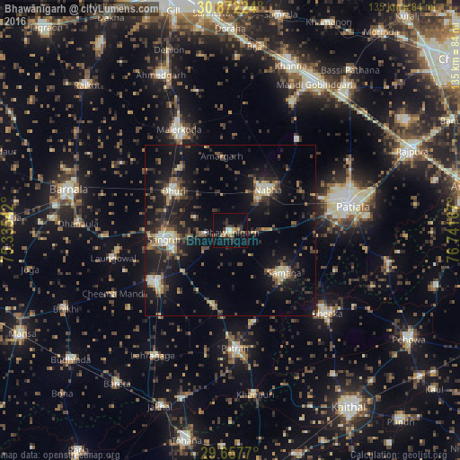
Analysis of Bhawānīgarh night lights 2016
Square area 10x10 km:
 0.92%
0.92%90-99
1.47%80-89
2.2%70-79
1.83%60-69
3.11%50-59
0.37%40-49
3.48%30-39
6.59%20-29
5.31%10-19
10.62%0-9
64.1%Square area 50x50 km:
0.55%90-99
1.8%80-89
2.06%70-79
1.34%60-69
1.36%50-59
2.26%40-49
3.42%30-39
3.54%20-29
4.99%10-19
15.7%0-9
62.98%Clear (daylight) street map image can be seen on geolist.org.
Map coordinates:
30° 52' 20.1" North, 75° 20' 7.5" East
30° 16' 0.7" North, 76° 2' 18.7" East
29° 39' 27.7" North, 76° 44' 30" East
Some cities around Bhawānīgarh sort by population:
• Patiāla
34.8 km =21.6 mi,  77°
77°
• Māler Kotla
33.1 km =20.6 mi,  332°
332°
• Sangrūr
18.8 km =11.7 mi,  262°
262°
• Nābha
16.3 km =10.1 mi,  42°
42°
• Dhūri
19.9 km =12.4 mi,  304°
304°
• Sunām
27.6 km =17.1 mi,  236°
236°
• Laungowāl
35.3 km =21.9 mi, 256°
• Dirba
22 km =13.7 mi,  190°
190°
1276026 (p: 19,376)
Sources (retrieved 2019-11-25):
» Earth at Night: Flat Maps 2012, 2016