Dirba night lights from space
Night Light of Dirba (Punjab) from space (India) Src. Average luminocity for 10x10km area is 9.964% and for 50x50km: 13.8592%.
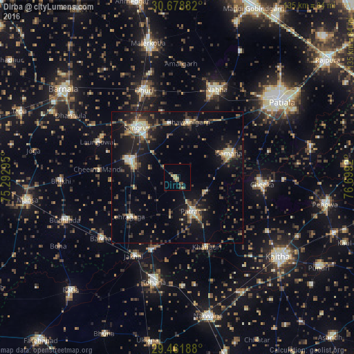
Analysis of Dirba night lights 2016
Square area 10x10 km:
100  0%
0%
90-99 0%
80-89 2.08%
70-79 1.89%
60-69 2.08%
50-59 0.95%
40-49 3.22%
30-39 1.89%
20-29 1.7%
10-19 1.33%
0-9 84.85%
0%90-99
0%80-89
2.08%70-79
1.89%60-69
2.08%50-59
0.95%40-49
3.22%30-39
1.89%20-29
1.7%10-19
1.33%0-9
84.85%Square area 50x50 km:
100 0.46%
90-99 1.49%
80-89 1.81%
70-79 1.27%
60-69 1.52%
50-59 2.31%
40-49 3.16%
30-39 3.18%
20-29 4.35%
10-19 11.6%
0-9 68.86%
0.46%90-99
1.49%80-89
1.81%70-79
1.27%60-69
1.52%50-59
2.31%40-49
3.16%30-39
3.18%20-29
4.35%10-19
11.6%0-9
68.86%Clear (daylight) street map image can be seen on geolist.org.
Map coordinates:
30° 40' 43.8" North, 75° 17' 34.6" East
30° 4' 20" North, 75° 59' 45.9" East
29° 27' 42.8" North, 76° 41' 57.1" East
Some cities around Dirba sort by population:
• Sangrūr
24.1 km =15 mi,  322°
322°
• Nābha
37 km =23 mi,  24°
24°
• Dhūri
35.2 km =21.9 mi,  339°
339°
• Sunām
19.9 km =12.4 mi,  288°
288°
• Laungowāl
33.2 km =20.6 mi, 294°
• Bhawānīgarh
22 km =13.7 mi,  10°
10°
• Jākhal
34.9 km =21.7 mi,  208°
208°
• Akālgarh
29.7 km =18.5 mi,  199°
199°
1272517 (p: 13,838)
Sources (retrieved 2019-11-25):
» Earth at Night: Flat Maps 2012, 2016