Āthagarh night lights from space
Night Light of Āthagarh (Odisha) from space (India) Src. Average luminocity for 10x10km area is 29.8807% and for 50x50km: 22.5784%.
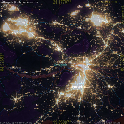
Analysis of Āthagarh night lights 2016
Square area 10x10 km:
 0.38%
0.38%90-99
1.14%80-89
1.33%70-79
3.41%60-69
3.6%50-59
8.14%40-49
10.61%30-39
15.34%20-29
10.04%10-19
35.04%0-9
10.98%Square area 50x50 km:
2.13%90-99
3.79%80-89
2.31%70-79
3.26%60-69
2.91%50-59
4.29%40-49
5.08%30-39
4.83%20-29
5.81%10-19
11.41%0-9
54.17%Clear (daylight) street map image can be seen on geolist.org.
Map coordinates:
21° 10' 37.5" North, 84° 55' 35.5" East
20° 31' 12" North, 85° 37' 46.7" East
19° 51' 36.3" North, 86° 19' 58" East
Some cities around Āthagarh sort by population:
• Bhubaneshwar
34.8 km =21.6 mi,  142°
142°
• Cuttack
26.7 km =16.6 mi,  103°
103°
• Dhenkānāl
15.7 km =9.8 mi,  347°
347°
• Jatani
40.9 km =25.4 mi,  168°
168°
• Khurda
37.5 km =23.3 mi,  182°
182°
• Bhuban
45.5 km =28.3 mi,  27°
27°
• Bānki
18.8 km =11.7 mi,  213°
213°
• Kāmākhyānagar
46.9 km =29.1 mi, 349°
1278216 (p: 16,665)
Sources (retrieved 2019-11-25):
» Earth at Night: Flat Maps 2012, 2016