Baikunthpur night lights from space
Night Light of Baikunthpur (Chhattisgarh) from space (India) Src. Average luminocity for 10x10km area is 27.1098% and for 50x50km: 5.9967%.
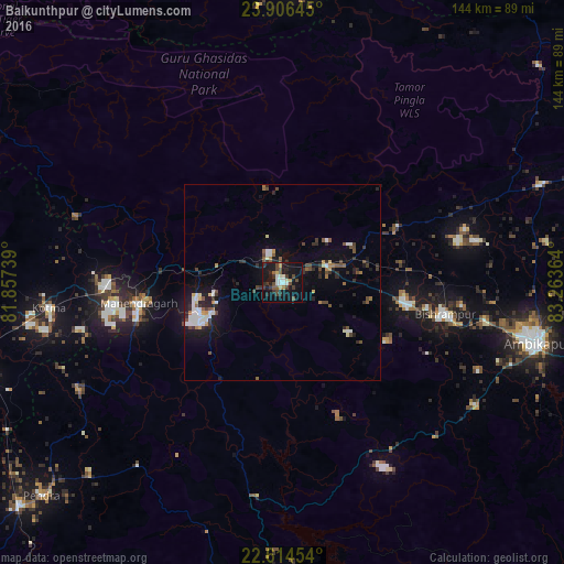
Analysis of Baikunthpur night lights 2016
Square area 10x10 km:
 3.03%
3.03%90-99
4.73%80-89
2.08%70-79
1.52%60-69
1.33%50-59
3.41%40-49
7.95%30-39
7.2%20-29
5.11%10-19
37.5%0-9
26.14%Square area 50x50 km:
0.79%90-99
1%80-89
0.37%70-79
0.34%60-69
0.53%50-59
0.8%40-49
1.22%30-39
1.08%20-29
1.59%10-19
4.87%0-9
87.41%Clear (daylight) street map image can be seen on geolist.org.
Map coordinates:
23° 54' 23.2" North, 81° 51' 26.6" East
23° 15' 43.4" North, 82° 33' 37.8" East
22° 36' 52.3" North, 83° 15' 49.1" East
Some cities around Baikunthpur sort by population:
• Korba
102.8 km =63.9 mi,  172°
172°
• Ambikāpur
66.8 km =41.5 mi,  103°
103°
• Kotma
59.8 km =37.2 mi,  263°
263°
• Pasān
59.4 km =36.9 mi,  218°
218°
• Katghora
84.5 km =52.5 mi,  181°
181°
• Anūppur
90.6 km =56.3 mi, 258°
• Gaurela
88 km =54.7 mi,  230°
230°
• Pendra
81.9 km =50.9 mi, 228°
1277769 (p: 10,790)
Sources (retrieved 2019-11-25):
» Earth at Night: Flat Maps 2012, 2016