Bāg night lights from space
Night Light of Bāg (Madhya Pradesh) from space (India) Src. Average luminocity for 10x10km area is 1.8826% and for 50x50km: 2.2381%.
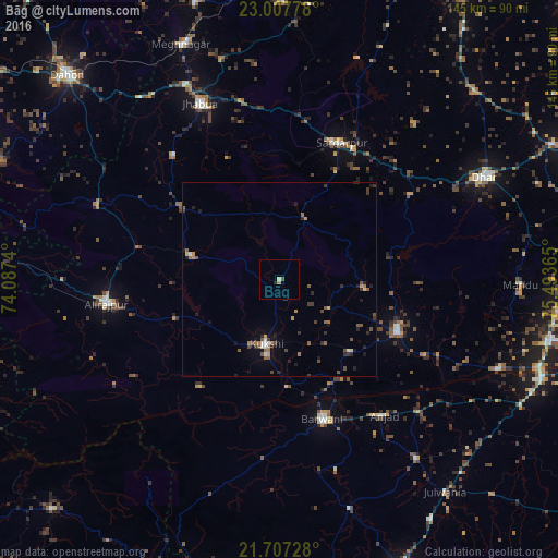
Analysis of Bāg night lights 2016
Square area 10x10 km:
 0%
0%90-99
0.19%80-89
0.57%70-79
0%60-69
0.76%50-59
0.19%40-49
0.57%30-39
0%20-29
0.38%10-19
0.38%0-9
96.97%Square area 50x50 km:
0.04%90-99
0.26%80-89
0.12%70-79
0.3%60-69
0.35%50-59
0.61%40-49
0.38%30-39
0.5%20-29
0.67%10-19
0.64%0-9
96.12%Clear (daylight) street map image can be seen on geolist.org.
Map coordinates:
23° 0' 28" North, 74° 5' 14.6" East
22° 21' 32.6" North, 74° 47' 25.9" East
21° 42' 26.2" North, 75° 29' 37.1" East
Some cities around Bāg sort by population:
• Barwāni
38 km =23.6 mi,  162°
162°
• Manāwar
33.6 km =20.9 mi,  114°
114°
• Rajpur
45.1 km =28 mi,  262°
262°
• Kukshi
17.3 km =10.7 mi,  191°
191°
• Anjad
44.6 km =27.7 mi,  142°
142°
• Rājgarh
38.9 km =24.2 mi,  24°
24°
• Jobat
23.7 km =14.7 mi,  285°
285°
• Rānāpur
42.3 km =26.3 mi,  319°
319°
1277905 (p: 7,764)
Sources (retrieved 2019-11-25):
» Earth at Night: Flat Maps 2012, 2016