Badnāwar night lights from space
Night Light of Badnāwar (Madhya Pradesh) from space (India) Src. Average luminocity for 10x10km area is 16.9524% and for 50x50km: 5.0677%.
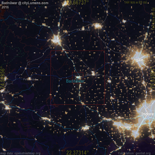
Analysis of Badnāwar night lights 2016
Square area 10x10 km:
 1.39%
1.39%90-99
2.98%80-89
1.98%70-79
0.2%60-69
2.18%50-59
3.17%40-49
1.19%30-39
3.97%20-29
3.97%10-19
12.9%0-9
66.07%Square area 50x50 km:
0.08%90-99
0.38%80-89
0.4%70-79
0.27%60-69
0.72%50-59
1%40-49
1.28%30-39
1.53%20-29
2.05%10-19
1.92%0-9
90.37%Clear (daylight) street map image can be seen on geolist.org.
Map coordinates:
23° 40' 2.5" North, 74° 31' 46.4" East
23° 1' 18.5" North, 75° 13' 57.6" East
22° 22' 23.3" North, 75° 56' 8.9" East
Some cities around Badnāwar sort by population:
• Ratlām
39.5 km =24.5 mi,  330°
330°
• Dhār
48.1 km =29.9 mi,  172°
172°
• Khāchrod
44.9 km =27.9 mi,  6°
6°
• Rājgarh
48.3 km =30 mi,  217°
217°
• Depālpur
37 km =23 mi,  120°
120°
• Gautampura
29.6 km =18.4 mi,  97°
97°
• Petlāwad
44.5 km =27.7 mi,  268°
268°
• Piploda
41.9 km =26 mi,  29°
29°
1277970 (p: 18,790)
Sources (retrieved 2019-11-25):
» Earth at Night: Flat Maps 2012, 2016