Depālpur night lights from space
Night Light of Depālpur (Madhya Pradesh) from space (India) Src. Average luminocity for 10x10km area is 14.5556% and for 50x50km: 14.3173%.
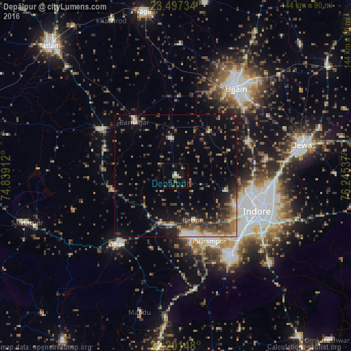
Analysis of Depālpur night lights 2016
Square area 10x10 km:
 0.4%
0.4%90-99
0.79%80-89
2.78%70-79
1.19%60-69
2.58%50-59
2.78%40-49
0.79%30-39
4.56%20-29
3.17%10-19
0.99%0-9
79.96%Square area 50x50 km:
0.57%90-99
1.62%80-89
1.01%70-79
1.53%60-69
2.48%50-59
2.69%40-49
3.25%30-39
4.4%20-29
4.47%10-19
6.79%0-9
71.2%Clear (daylight) street map image can be seen on geolist.org.
Map coordinates:
23° 29' 50.4" North, 74° 50' 20.8" East
22° 51' 3.4" North, 75° 32' 32.1" East
22° 12' 5.3" North, 76° 14' 43.3" East
Some cities around Depālpur sort by population:
• Indore
33.3 km =20.7 mi,  116°
116°
• Dhār
38 km =23.6 mi,  221°
221°
• Pithampur
31.9 km =19.8 mi,  150°
150°
• Badnāwar
37 km =23 mi,  300°
300°
• Gautampura
15.3 km =9.5 mi,  351°
351°
• Sānwer
32.2 km =20 mi,  64°
64°
• Betma
19.7 km =12.2 mi,  157°
157°
• Hātod
21.2 km =13.2 mi,  107°
107°
1273181 (p: 16,936)
Sources (retrieved 2019-11-25):
» Earth at Night: Flat Maps 2012, 2016