Bachhrāwān night lights from space
Night Light of Bachhrāwān (Uttar Pradesh) from space (India) Src. Average luminocity for 10x10km area is 26.7689% and for 50x50km: 15.452%.
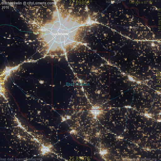
Analysis of Bachhrāwān night lights 2016
Square area 10x10 km:
 1.14%
1.14%90-99
2.46%80-89
1.14%70-79
1.33%60-69
1.7%50-59
8.9%40-49
8.9%30-39
8.33%20-29
7.01%10-19
45.08%0-9
14.02%Square area 50x50 km:
0.52%90-99
0.96%80-89
0.8%70-79
1.34%60-69
1.43%50-59
2.92%40-49
4.44%30-39
5.59%20-29
7.42%10-19
16.69%0-9
57.89%Clear (daylight) street map image can be seen on geolist.org.
Map coordinates:
27° 5' 54.9" North, 80° 24' 45.6" East
26° 28' 15.2" North, 81° 6' 56.9" East
25° 50' 23.2" North, 81° 49' 8.1" East
Some cities around Bachhrāwān sort by population:
• Raebareli
29.1 km =18.1 mi,  156°
156°
• Purwā
34.1 km =21.2 mi,  267°
267°
• Maurānwān
23.9 km =14.9 mi,  258°
258°
• Satrikh
44 km =27.3 mi,  10°
10°
• Nagrām
16.6 km =10.3 mi, 8°
• Goshāīnganj
33 km =20.5 mi,  358°
358°
• Bhagwantnagar
45 km =28 mi,  232°
232°
• Mahārājganj
18.7 km =11.6 mi,  122°
122°
1278035 (p: 12,809)
Sources (retrieved 2019-11-25):
» Earth at Night: Flat Maps 2012, 2016