Bābai night lights from space
Night Light of Bābai (Madhya Pradesh) from space (India) Src. Average luminocity for 10x10km area is 15.7183% and for 50x50km: 10.7903%.
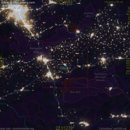
Analysis of Bābai night lights 2016
Square area 10x10 km:
 0%
0%90-99
1.79%80-89
1.79%70-79
3.17%60-69
2.78%50-59
3.17%40-49
0.6%30-39
3.97%20-29
1.79%10-19
1.59%0-9
79.37%Square area 50x50 km:
0.88%90-99
1.5%80-89
0.98%70-79
0.87%60-69
1.54%50-59
1.83%40-49
1.65%30-39
1.96%20-29
3.56%10-19
7.42%0-9
77.81%Clear (daylight) street map image can be seen on geolist.org.
Map coordinates:
23° 20' 58.8" North, 77° 13' 54.6" East
22° 42' 9.2" North, 77° 56' 5.8" East
22° 3' 8.6" North, 78° 38' 17.1" East
Some cities around Bābai sort by population:
• Hoshangābād
21.9 km =13.6 mi,  283°
283°
• Itārsi
20.2 km =12.6 mi,  241°
241°
• Mandideep
58.9 km =36.6 mi,  315°
315°
• Seoni Mālwa
55.7 km =34.6 mi, 239°
• Sohāgpur
26.7 km =16.6 mi,  90°
90°
• Nasrullāhganj
68.2 km =42.4 mi,  268°
268°
• Rehti
51.5 km =32 mi, 274°
• Sultānpur
48.4 km =30.1 mi,  359°
359°
1278073 (p: 16,176)
Sources (retrieved 2019-11-25):
» Earth at Night: Flat Maps 2012, 2016