Kāmākhyānagar night lights from space
Night Light of Kāmākhyānagar (Odisha) from space (India) Src. Average luminocity for 10x10km area is 28.7956% and for 50x50km: 12.406%.
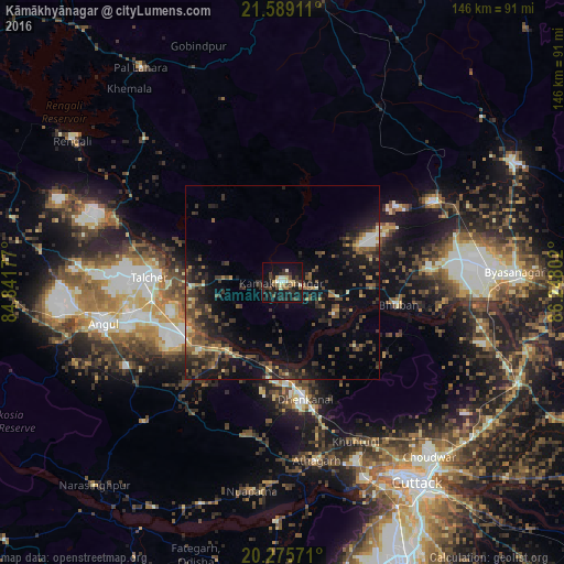
Analysis of Kāmākhyānagar night lights 2016
Square area 10x10 km:
 1.59%
1.59%90-99
4.37%80-89
4.76%70-79
2.78%60-69
0.79%50-59
3.57%40-49
6.15%30-39
8.73%20-29
11.31%10-19
33.73%0-9
22.22%Square area 50x50 km:
0.37%90-99
0.92%80-89
0.9%70-79
1.15%60-69
1.46%50-59
3.13%40-49
3.26%30-39
3.83%20-29
5.07%10-19
10.77%0-9
69.13%Clear (daylight) street map image can be seen on geolist.org.
Map coordinates:
21° 35' 20.8" North, 84° 50' 30.4" East
20° 56' 1.9" North, 85° 32' 41.6" East
20° 16' 32.6" North, 86° 14' 52.9" East
Some cities around Kāmākhyānagar sort by population:
• Cuttack
62.7 km =39 mi,  146°
146°
• Dhenkānāl
31.2 km =19.4 mi,  170°
170°
• Angul
47.2 km =29.3 mi,  257°
257°
• Tālcher
32.4 km =20.1 mi,  273°
273°
• Bhuban
30.5 km =19 mi,  100°
100°
• Āthagarh
46.9 km =29.1 mi, 169°
• Bānki
61.7 km =38.3 mi,  181°
181°
• Kantilo
73.5 km =45.7 mi,  209°
209°
1268279 (p: 15,818)
Sources (retrieved 2019-11-25):
» Earth at Night: Flat Maps 2012, 2016