Kānkon night lights from space
Night Light of Kānkon (Goa) from space (India) Src. Average luminocity for 10x10km area is 15.7231% and for 50x50km: 7.5284%.
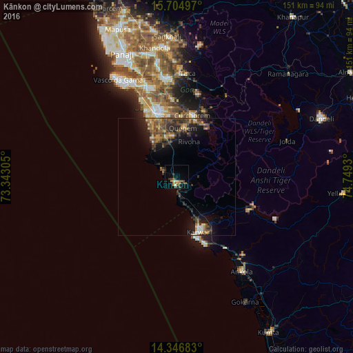
Analysis of Kānkon night lights 2016
Square area 10x10 km:
 0.41%
0.41%90-99
1.45%80-89
1.45%70-79
3.1%60-69
3.31%50-59
2.69%40-49
4.55%30-39
3.31%20-29
0.83%10-19
3.93%0-9
75%Square area 50x50 km:
0.3%90-99
0.69%80-89
0.61%70-79
1.09%60-69
1.13%50-59
1.87%40-49
2.05%30-39
1.95%20-29
2.53%10-19
4.65%0-9
83.13%Clear (daylight) street map image can be seen on geolist.org.
Map coordinates:
15° 42' 17.9" North, 73° 20' 35" East
15° 1' 37.1" North, 74° 2' 46.2" East
14° 20' 48.6" North, 74° 44' 57.5" East
Some cities around Kānkon sort by population:
• Karwar
25.4 km =15.8 mi,  159°
159°
• Cuncolim
17.6 km =10.9 mi,  341°
341°
• Quepem
20.9 km =13 mi,  9°
9°
• Cavelossim
19.7 km =12.2 mi,  325°
325°
• Canacona
3.5 km =2.2 mi,  172°
172°
• Chinchinim
22.2 km =13.8 mi, 340°
• Sanguem
25.1 km =15.6 mi,  26°
26°
• Varca
25.4 km =15.8 mi, 334°
1268022 (p: 12,444)
Sources (retrieved 2019-11-25):
» Earth at Night: Flat Maps 2012, 2016