Ghumārwīn night lights from space
Night Light of Ghumārwīn (Himachal Pradesh) from space (India) Src. Average luminocity for 10x10km area is 4.049% and for 50x50km: 5.15%.
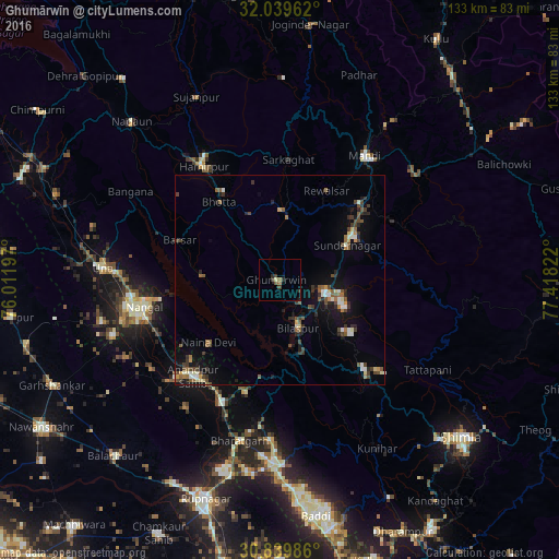
Analysis of Ghumārwīn night lights 2016
Square area 10x10 km:
 0%
0%90-99
0.17%80-89
0.52%70-79
0%60-69
0.7%50-59
1.22%40-49
0.35%30-39
2.62%20-29
1.4%10-19
0.7%0-9
92.31%Square area 50x50 km:
0.33%90-99
0.73%80-89
0.33%70-79
0.43%60-69
0.67%50-59
1.03%40-49
1.1%30-39
1.11%20-29
1.05%10-19
3.44%0-9
89.79%Clear (daylight) street map image can be seen on geolist.org.
Map coordinates:
32° 2' 22.6" North, 76° 0' 43.1" East
31° 26' 30" North, 76° 42' 54.3" East
30° 50' 23.5" North, 77° 25' 5.6" East
Some cities around Ghumārwīn sort by population:
• Nangal
32.7 km =20.3 mi,  259°
259°
• Mandi
36.4 km =22.6 mi,  34°
34°
• Sundarnagar
20.8 km =12.9 mi,  59°
59°
• Hamīrpur
32.4 km =20.1 mi,  326°
326°
• Anandpur
30.2 km =18.8 mi,  221°
221°
• Bilaspur
13 km =8.1 mi,  162°
162°
• Nūrpur Kalān
37.7 km =23.4 mi, 215°
• Santokhgarh
39 km =24.2 mi, 255°
1271393 (p: 6,690)
Sources (retrieved 2019-11-25):
» Earth at Night: Flat Maps 2012, 2016