Amod night lights from space
Night Light of Amod (Gujarat) from space (India) Src. Average luminocity for 10x10km area is 4.752% and for 50x50km: 13.8568%.
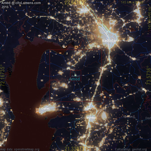
Analysis of Amod night lights 2016
Square area 10x10 km:
100  0%
0%
90-99 0.4%
80-89 0.4%
70-79 0.79%
60-69 0.4%
50-59 0%
40-49 1.59%
30-39 0%
20-29 1.79%
10-19 2.98%
0-9 91.67%
0%90-99
0.4%80-89
0.4%70-79
0.79%60-69
0.4%50-59
0%40-49
1.59%30-39
0%20-29
1.79%10-19
2.98%0-9
91.67%Square area 50x50 km:
100 0.23%
90-99 1.45%
80-89 1.49%
70-79 1.06%
60-69 2.04%
50-59 2.7%
40-49 2.9%
30-39 3.25%
20-29 4.74%
10-19 16.34%
0-9 63.8%
0.23%90-99
1.45%80-89
1.49%70-79
1.06%60-69
2.04%50-59
2.7%40-49
2.9%30-39
3.25%20-29
4.74%10-19
16.34%0-9
63.8%Clear (daylight) street map image can be seen on geolist.org.
Map coordinates:
22° 38' 37" North, 72° 10' 2.5" East
21° 59' 35.4" North, 72° 52' 13.7" East
21° 20' 23" North, 73° 34' 25" East
Some cities around Amod sort by population:
• Bharūch
35.1 km =21.8 mi,  161°
161°
• Khambhāt
44.4 km =27.6 mi,  324°
324°
• Ankleshwar
42 km =26.1 mi, 162°
• Borsad
46.2 km =28.7 mi,  3°
3°
• Jambusar
9.7 km =6 mi,  312°
312°
• Padra
35.2 km =21.9 mi,  38°
38°
• Hansot
45.8 km =28.5 mi,  188°
188°
• Dhuwaran
29.5 km =18.3 mi,  337°
337°
1278742 (p: 18,742)
Sources (retrieved 2019-11-25):
» Earth at Night: Flat Maps 2012, 2016