Dhuwaran night lights from space
Night Light of Dhuwaran (Gujarat) from space (India) Src. Average luminocity for 10x10km area is 9.2595% and for 50x50km: 13.32%.
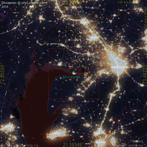
Analysis of Dhuwaran night lights 2016
Square area 10x10 km:
 0.95%
0.95%90-99
1.33%80-89
0.76%70-79
1.33%60-69
0.38%50-59
1.7%40-49
0.95%30-39
0.95%20-29
0.76%10-19
1.7%0-9
89.2%Square area 50x50 km:
0.1%90-99
1.04%80-89
1.04%70-79
1.27%60-69
1.8%50-59
2.84%40-49
3.46%30-39
4.4%20-29
6.03%10-19
11.89%0-9
66.12%Clear (daylight) street map image can be seen on geolist.org.
Map coordinates:
22° 53' 13.5" North, 72° 3' 21.5" East
22° 14' 16" North, 72° 45' 32.8" East
21° 35' 7.7" North, 73° 27' 44" East
Some cities around Dhuwaran sort by population:
• Khambhāt
16.9 km =10.5 mi,  301°
301°
• Borsad
23.7 km =14.7 mi,  37°
37°
• Petlād
26.9 km =16.7 mi,  8°
8°
• Jambusar
21.1 km =13.1 mi,  168°
168°
• Padra
33.5 km =20.8 mi,  89°
89°
• Vallabh Vidyanagar
35.9 km =22.3 mi,  23°
23°
• Sojītra
33.7 km =20.9 mi,  353°
353°
• Amod
29.5 km =18.3 mi,  157°
157°
1272660 (p: 11,473)
Sources (retrieved 2019-11-25):
» Earth at Night: Flat Maps 2012, 2016