Āmlāgora night lights from space
Night Light of Āmlāgora (West Bengal) from space (India) Src. Average luminocity for 10x10km area is 26.3413% and for 50x50km: 8.8589%.
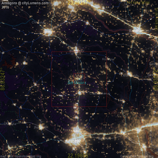
Analysis of Āmlāgora night lights 2016
Square area 10x10 km:
 0.2%
0.2%90-99
1.59%80-89
1.79%70-79
2.58%60-69
4.37%50-59
6.15%40-49
9.52%30-39
6.94%20-29
9.72%10-19
38.89%0-9
18.25%Square area 50x50 km:
0.17%90-99
0.55%80-89
0.36%70-79
0.64%60-69
0.86%50-59
1.47%40-49
3.04%30-39
3.18%20-29
3.87%10-19
7.57%0-9
78.3%Clear (daylight) street map image can be seen on geolist.org.
Map coordinates:
23° 29' 33.3" North, 86° 37' 56.9" East
22° 50' 46.2" North, 87° 20' 8.1" East
22° 11' 48" North, 88° 2' 19.4" East
Some cities around Āmlāgora sort by population:
• Medinīpur
47.3 km =29.4 mi,  181°
181°
• Bishnupur
25.4 km =15.8 mi,  356°
356°
• Arāmbāgh
46.1 km =28.6 mi,  84°
84°
• Ghātāl
45.7 km =28.4 mi,  116°
116°
• Chandrakona
22.4 km =13.9 mi, 124°
• Rāmjībanpur
28.1 km =17.5 mi,  94°
94°
• Kharar
37.7 km =23.4 mi,  111°
111°
• Pātrasāer
43.9 km =27.3 mi,  27°
27°
1278774 (p: 19,038)
Sources (retrieved 2019-11-25):
» Earth at Night: Flat Maps 2012, 2016