Kharar night lights from space
Night Light of Kharar (West Bengal) from space (India) Src. Average luminocity for 10x10km area is 1.7976% and for 50x50km: 8.2088%.
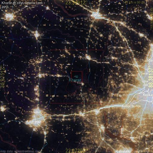
Analysis of Kharar night lights 2016
Square area 10x10 km:
 0%
0%90-99
0%80-89
0%70-79
0%60-69
0%50-59
0%40-49
0.79%30-39
0.79%20-29
1.79%10-19
0.6%0-9
96.03%Square area 50x50 km:
0.12%90-99
0.4%80-89
0.38%70-79
0.63%60-69
0.63%50-59
1.26%40-49
2.87%30-39
3.2%20-29
4.52%10-19
5.63%0-9
80.37%Clear (daylight) street map image can be seen on geolist.org.
Map coordinates:
23° 22' 8.8" North, 86° 58' 30.4" East
22° 43' 19.6" North, 87° 40' 41.7" East
22° 4' 19.3" North, 88° 22' 52.9" East
Some cities around Kharar sort by population:
• Arāmbāgh
20.9 km =13 mi,  31°
31°
• Ghātāl
8.8 km =5.5 mi,  139°
139°
• Tarakeswar
38.9 km =24.2 mi,  62°
62°
• Chandrakona
16.6 km =10.3 mi,  274°
274°
• Āmlāgora
37.7 km =23.4 mi,  291°
291°
• Rāmjībanpur
13.8 km =8.6 mi,  328°
328°
• Āmta
37.4 km =23.2 mi,  114°
114°
• Bāli Chak
41.8 km =26 mi,  197°
197°
1266962 (p: 12,049)
Sources (retrieved 2019-11-25):
» Earth at Night: Flat Maps 2012, 2016