Pātrasāer night lights from space
Night Light of Pātrasāer (West Bengal) from space (India) Src. Average luminocity for 10x10km area is 6.6458% and for 50x50km: 9.6992%.
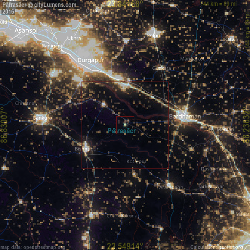
Analysis of Pātrasāer night lights 2016
Square area 10x10 km:
 0%
0%90-99
0%80-89
0.76%70-79
0%60-69
0.76%50-59
1.14%40-49
0.76%30-39
2.84%20-29
7.39%10-19
2.27%0-9
84.09%Square area 50x50 km:
0.33%90-99
1.01%80-89
0.72%70-79
0.65%60-69
1.07%50-59
2.03%40-49
2.26%30-39
2.86%20-29
4.43%10-19
7.42%0-9
77.23%Clear (daylight) street map image can be seen on geolist.org.
Map coordinates:
23° 50' 30" North, 86° 49' 48.3" East
23° 11' 49.1" North, 87° 31' 59.5" East
22° 32' 56.9" North, 88° 14' 10.8" East
Some cities around Pātrasāer sort by population:
• Durgapur
42.3 km =26.3 mi,  327°
327°
• Barddhamān
33.7 km =20.9 mi,  78°
78°
• Bishnupur
25.8 km =16 mi,  237°
237°
• Guskhara
38.8 km =24.1 mi,  32°
32°
• Sonāmukhi
17.2 km =10.7 mi,  314°
314°
• Rāmjībanpur
41.7 km =25.9 mi,  169°
169°
• Barjora
35.7 km =22.2 mi,  315°
315°
• Beliātor
34.7 km =21.6 mi,  293°
293°
1260064 (p: 11,520)
Sources (retrieved 2019-11-25):
» Earth at Night: Flat Maps 2012, 2016