Ambahta night lights from space
Night Light of Ambahta (Uttar Pradesh) from space (India) Src. Average luminocity for 10x10km area is 25.8155% and for 50x50km: 27.1827%.
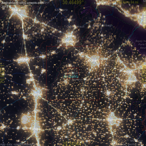
Analysis of Ambahta night lights 2016
Square area 10x10 km:
 0.79%
0.79%90-99
0%80-89
0.79%70-79
1.98%60-69
1.98%50-59
9.13%40-49
7.34%30-39
9.13%20-29
20.44%10-19
28.97%0-9
19.44%Square area 50x50 km:
1.67%90-99
3.15%80-89
2.77%70-79
2.63%60-69
3.3%50-59
5.67%40-49
7.47%30-39
6.44%20-29
10.71%10-19
24.81%0-9
31.39%Clear (daylight) street map image can be seen on geolist.org.
Map coordinates:
30° 27' 54" North, 76° 37' 57.8" East
29° 51' 25.4" North, 77° 20' 9" East
29° 14' 43.5" North, 78° 2' 20.3" East
Some cities around Ambahta sort by population:
• Sahāranpur
23.6 km =14.7 mi,  58°
58°
• Gangoh
11 km =6.8 mi,  219°
219°
• Rāmpur
12.6 km =7.8 mi,  116°
116°
• Nakūr
7.6 km =4.7 mi,  336°
336°
• Nanauta
17.9 km =11.1 mi,  153°
153°
• Indri
26.7 km =16.6 mi,  275°
275°
• Radaur
25.9 km =16.1 mi,  316°
316°
• Titron
21 km =13 mi,  183°
183°
1278867 (p: 14,303)
Sources (retrieved 2019-11-25):
» Earth at Night: Flat Maps 2012, 2016