Titron night lights from space
Night Light of Titron (Uttar Pradesh) from space (India) Src. Average luminocity for 10x10km area is 19.1647% and for 50x50km: 25.2387%.
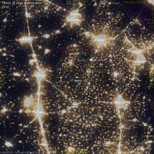
Analysis of Titron night lights 2016
Square area 10x10 km:
 0.99%
0.99%90-99
0.6%80-89
0%70-79
0.99%60-69
1.59%50-59
2.58%40-49
8.33%30-39
6.15%20-29
5.56%10-19
36.11%0-9
37.1%Square area 50x50 km:
0.8%90-99
1.85%80-89
1.47%70-79
2.07%60-69
3.19%50-59
5.12%40-49
7.97%30-39
6.71%20-29
11.64%10-19
37.07%0-9
22.12%Clear (daylight) street map image can be seen on geolist.org.
Map coordinates:
30° 16' 38.4" North, 76° 37' 14.8" East
29° 40' 5.7" North, 77° 19' 26.1" East
29° 3' 19.6" North, 78° 1' 37.3" East
Some cities around Titron sort by population:
• Gangoh
13.7 km =8.5 mi,  334°
334°
• Thāna Bhawan
12.9 km =8 mi,  135°
135°
• Rāmpur
19.7 km =12.2 mi,  38°
38°
• Jalālābad
12.4 km =7.7 mi,  116°
116°
• Jhinjhāna
19 km =11.8 mi,  210°
210°
• Nanauta
10.3 km =6.4 mi,  61°
61°
• Ūn
11.4 km =7.1 mi,  215°
215°
• Garhi Pūkhta
13.2 km =8.2 mi,  186°
186°
1254302 (p: 11,569)
Sources (retrieved 2019-11-25):
» Earth at Night: Flat Maps 2012, 2016