Indri night lights from space
Night Light of Indri (Haryana) from space (India) Src. Average luminocity for 10x10km area is 22.1548% and for 50x50km: 25.7172%.
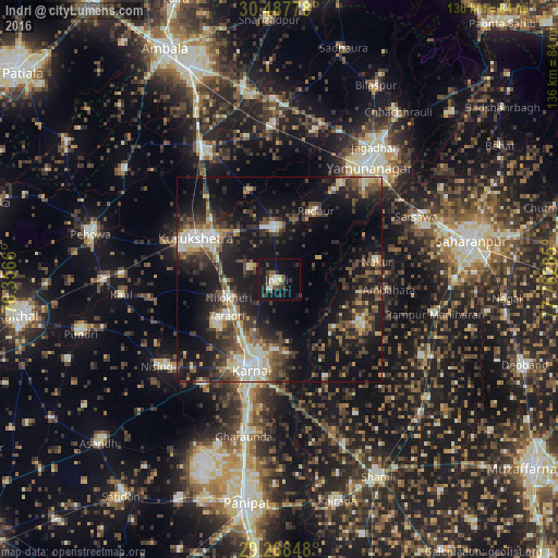
Analysis of Indri night lights 2016
Square area 10x10 km:
100  1.79%
1.79%
90-99 3.57%
80-89 2.78%
70-79 2.18%
60-69 0%
50-59 2.38%
40-49 6.94%
30-39 3.97%
20-29 6.35%
10-19 28.57%
0-9 41.47%
1.79%90-99
3.57%80-89
2.78%70-79
2.18%60-69
0%50-59
2.38%40-49
6.94%30-39
3.97%20-29
6.35%10-19
28.57%0-9
41.47%Square area 50x50 km:
100 2.23%
90-99 4.29%
80-89 2.94%
70-79 2.13%
60-69 2.22%
50-59 4.44%
40-49 5.9%
30-39 6.36%
20-29 8.77%
10-19 21.7%
0-9 39.01%
2.23%90-99
4.29%80-89
2.94%70-79
2.13%60-69
2.22%50-59
4.44%40-49
5.9%30-39
6.36%20-29
8.77%10-19
21.7%0-9
39.01%Clear (daylight) street map image can be seen on geolist.org.
Map coordinates:
30° 29' 16" North, 76° 21' 23.8" East
29° 52' 48" North, 77° 3' 35" East
29° 16' 6.5" North, 77° 45' 46.3" East
Some cities around Indri sort by population:
• Karnāl
22.1 km =13.7 mi,  199°
199°
• Thānesar
24.3 km =15.1 mi,  295°
295°
• Gangoh
22.6 km =14 mi,  119°
119°
• Lādwa
12.7 km =7.9 mi,  353°
353°
• Nakūr
24 km =14.9 mi,  79°
79°
• Nīlokheri
13.2 km =8.2 mi,  248°
248°
• Ambahta
26.7 km =16.6 mi,  95°
95°
• Radaur
18.6 km =11.6 mi,  28°
28°
1269731 (p: 15,954)
Sources (retrieved 2019-11-25):
» Earth at Night: Flat Maps 2012, 2016