Valavanur night lights from space
Night Light of Valavanur (Tamil Nadu) from space (India) Src. Average luminocity for 10x10km area is 37.9959% and for 50x50km: 27.3646%.
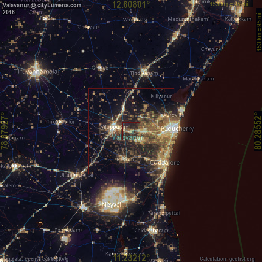
Analysis of Valavanur night lights 2016
Square area 10x10 km:
 0%
0%90-99
1.45%80-89
3.72%70-79
3.72%60-69
2.89%50-59
9.92%40-49
13.22%30-39
24.38%20-29
31.82%10-19
8.88%0-9
0%Square area 50x50 km:
0.43%90-99
2.42%80-89
4.27%70-79
4.23%60-69
3.22%50-59
6.71%40-49
8.6%30-39
7.64%20-29
10.41%10-19
14.55%0-9
37.52%Clear (daylight) street map image can be seen on geolist.org.
Map coordinates:
12° 36' 28.8" North, 78° 52' 45.4" East
11° 55' 15.4" North, 79° 34' 56.6" East
11° 13' 55.6" North, 80° 17' 7.9" East
Some cities around Valavanur sort by population:
• Puducherry
27 km =16.8 mi,  86°
86°
• Cuddalore
27.2 km =16.9 mi,  132°
132°
• Villupuram
10 km =6.2 mi,  282°
282°
• Tindivanam
35.7 km =22.2 mi,  12°
12°
• Panruti
16.4 km =10.2 mi,  191°
191°
• Nellikkuppam
18.8 km =11.7 mi,  149°
149°
• Vikravāndi
13.5 km =8.4 mi,  342°
342°
• Ālappākkam
38.8 km =24.1 mi,  157°
157°
1253490 (p: 14,463)
Sources (retrieved 2019-11-25):
» Earth at Night: Flat Maps 2012, 2016