Alagāpuram night lights from space
Night Light of Alagāpuram (Tamil Nadu) from space (India) Src. Average luminocity for 10x10km area is 5.3202% and for 50x50km: 4.165%.
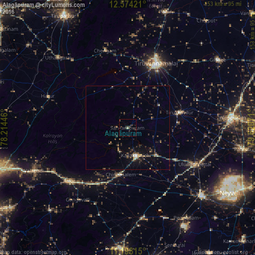
Analysis of Alagāpuram night lights 2016
Square area 10x10 km:
 0%
0%90-99
0%80-89
0.83%70-79
0%60-69
0%50-59
0%40-49
2.27%30-39
4.34%20-29
3.72%10-19
1.65%0-9
87.19%Square area 50x50 km:
0.01%90-99
0.39%80-89
0.22%70-79
0.39%60-69
0.27%50-59
0.66%40-49
1.12%30-39
1.7%20-29
1.99%10-19
2.77%0-9
90.49%Clear (daylight) street map image can be seen on geolist.org.
Map coordinates:
12° 34' 27.2" North, 78° 12' 52.1" East
11° 53' 13.4" North, 78° 55' 3.3" East
11° 11' 53.3" North, 79° 37' 14.6" East
Some cities around Alagāpuram sort by population:
• Tiruvannāmalai
41.4 km =25.7 mi,  24°
24°
• Attur
47.4 km =29.5 mi,  226°
226°
• Kallakkurichchi
16.9 km =10.5 mi,  164°
164°
• Tirukkoyilur
32.2 km =20 mi,  74°
74°
• Chengam
48.9 km =30.4 mi,  343°
343°
• Chinna Salem
28.5 km =17.7 mi,  189°
189°
• Vettavalam
43.3 km =26.9 mi,  55°
55°
• Manalūrpettai
23.2 km =14.4 mi,  54°
54°
1279084 (p: 8,345)
Sources (retrieved 2019-11-25):
» Earth at Night: Flat Maps 2012, 2016