Vettavalam night lights from space
Night Light of Vettavalam (Tamil Nadu) from space (India) Src. Average luminocity for 10x10km area is 3.6446% and for 50x50km: 8.4861%.
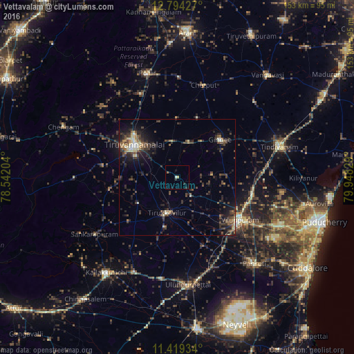
Analysis of Vettavalam night lights 2016
Square area 10x10 km:
 0%
0%90-99
0.83%80-89
0%70-79
0.83%60-69
0.62%50-59
0.21%40-49
0%30-39
1.03%20-29
1.45%10-19
2.48%0-9
92.56%Square area 50x50 km:
0.21%90-99
1.01%80-89
0.81%70-79
0.63%60-69
0.79%50-59
1.49%40-49
2.5%30-39
2.78%20-29
3.63%10-19
5.54%0-9
80.61%Clear (daylight) street map image can be seen on geolist.org.
Map coordinates:
12° 47' 39.4" North, 78° 32' 31.3" East
12° 6' 27.7" North, 79° 14' 42.6" East
11° 25' 9.6" North, 79° 56' 53.8" East
Some cities around Vettavalam sort by population:
• Tiruvannāmalai
22.8 km =14.2 mi,  305°
305°
• Villupuram
32.7 km =20.3 mi,  124°
124°
• Tirukkoyilur
16.4 km =10.2 mi,  196°
196°
• Gingee
24.7 km =15.3 mi,  49°
49°
• Valavanur
42.1 km =26.2 mi, 119°
• Vikravāndi
33.6 km =20.9 mi,  103°
103°
• Pennāthur
15.6 km =9.7 mi,  352°
352°
• Manalūrpettai
20 km =12.4 mi,  236°
236°
1253217 (p: 13,808)
Sources (retrieved 2019-11-25):
» Earth at Night: Flat Maps 2012, 2016